|
|
|
|
|
|
|

| 45o
26,5´N 13o 30,13´E |
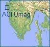
North-western
coast of Istria
HR-52470
UMAG
Tel.:+385 52 741 066
Fax.:+385 52 741 166
VHF Channel 17
Other
Marinas:

| General
remarks: When approaching the harbor the chimney of the cement factory located south of the town serves as a good landmark. The entrance into the ACI marina Umag lies half a mile north. Special attention should be paid to Paklena Shoal, half a mile on the northeastern side of the entrance to the harbor. Paklena Shoal is marked by a light (Fl (2) WR 8s 10m 8/6 M). Paklena Shoal (N 45°26,3' E 13°30,3') can be used as a way point. |
|
The harbor is open to the northwest and one must enter it between a red lighted (Fl R 3s 2M) and green unlighted buoy. To the north, next to the red buoy there is a black and yellow mark on a rock, which must be rounded from south. When approaching, it is recommended to keep to a course of 60°. The light positioned on the breakwater (Fl (3) R 3s 4m 8M) is visible after passing the described buoys. The sea depth in the marked channel is 4 m. |
|

;) ;) |
Map |
 |