Dračevo Polje (Vis): Beaches and Coves, Croatia
Dračevo Polje, located on the island of Vis in Croatia’s Adriatic Sea, is a coastal area defined by its rugged limestone cliffs, sheltered coves, and unspoiled natural landscapes. This part of the island’s eastern coast is characterized by a series of small, rocky inlets and shallow bays that offer a tranquil alternative to the more developed beaches of the island. The area is accessible via a winding road that connects to the main village of Vis, and its proximity to the island’s historic sites and maritime routes makes it a compelling destination for both land and sea exploration.
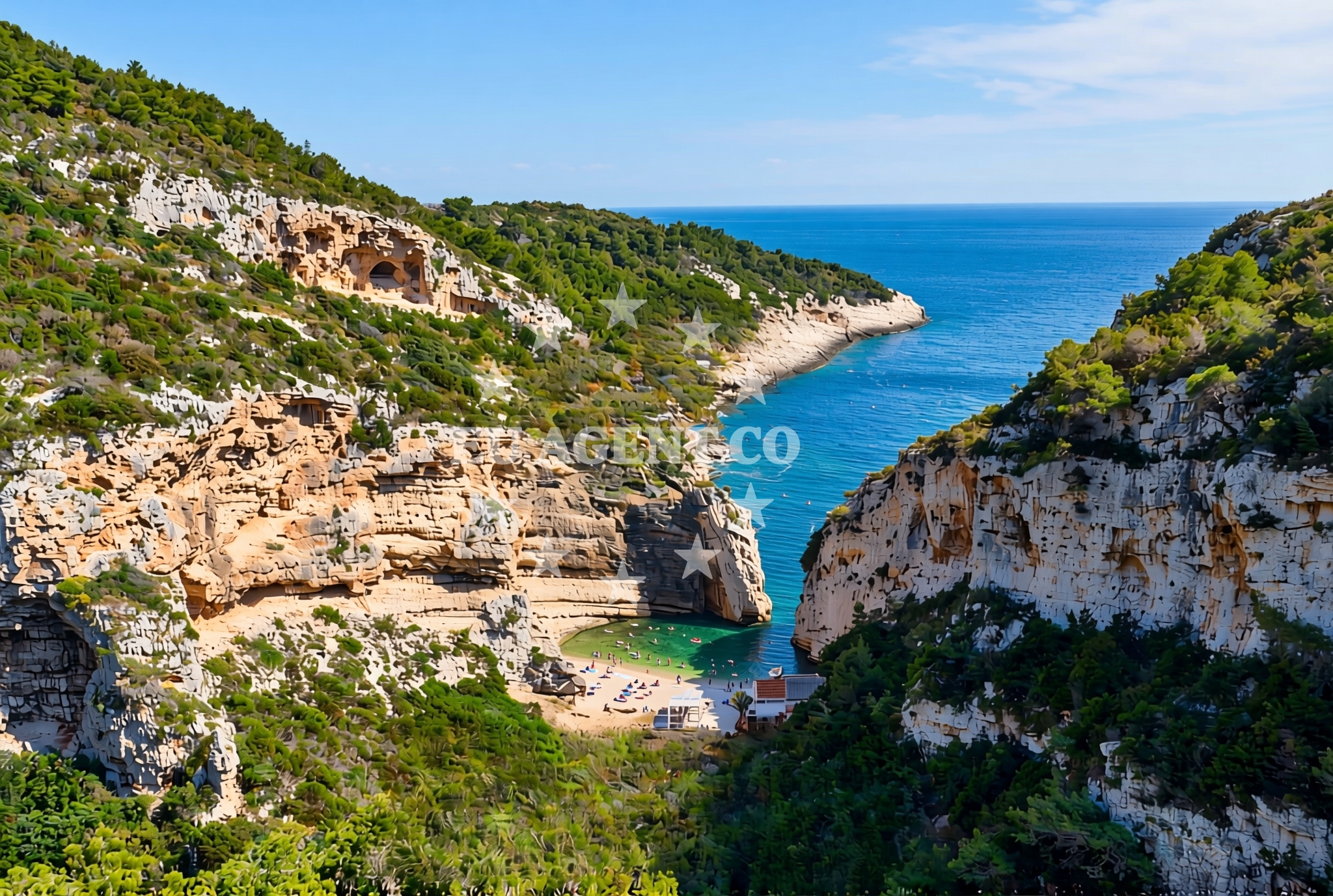
About this beach
Dračevo Polje (Vis): beaches and coves
Beach character
The beaches and coves of Dračevo Polje are defined by their natural, undeveloped character. The shoreline is composed of pebbles and small stones, with limited sandy patches concentrated in the more sheltered areas. The waters here are typically calm and clear, making it a suitable spot for swimming and snorkeling. The surrounding cliffs, which rise steeply from the shore, provide a dramatic backdrop and contribute to the area’s sense of seclusion. Unlike the more commercialized beaches on Vis, Dračevo Polje retains a raw, untouched quality that appeals to visitors seeking a quieter, more authentic coastal experience.
Swimming and shore
Swimming conditions in Dračevo Polje are generally favorable, with water temperatures that remain pleasant throughout the summer months. The shallow, sheltered coves are ideal for families and those seeking a relaxed swim, while the more exposed areas may see stronger currents. The shore itself is uneven, with rocky outcrops and pebbles dominating the beach profile. For those interested in water activities, the area’s proximity to the Blue Grotto—a sea cave accessible by boat—offers additional opportunities for exploration. However, the lack of formal beach amenities means visitors should come prepared with their own equipment and supplies.
Facilities and activities
There are no formal facilities or services directly at the beaches of Dračevo Polje. The area is not equipped with lifeguard stations, showers, or changing rooms, and parking is limited to the road that connects to the village of Vis. Activities centered around the beach include snorkeling, hiking along the island’s coastal trails, and boat excursions to nearby attractions such as the St. Nicholas Church and the island’s historic fortifications. The absence of commercial infrastructure means the area is best suited for visitors who prioritize natural beauty and solitude over convenience.
Access and location
Dračevo Polje is located on the eastern coast of Vis, approximately 8 kilometers from the island’s main village. The area is accessible via a narrow, winding road that runs parallel to the coastline. This road connects to the broader network of roads on Vis, which in turn links to the mainland via the bridge to the island of Hvar. For visitors arriving by sea, the nearest marinas are in the village of Vis and the port of Korcula on the mainland. The area’s relative isolation means that it is best reached by car or boat, with limited public transportation options available.
What to expect
Visitors to Dračevo Polje should expect a coastal experience that prioritizes natural beauty and seclusion. The beaches are undeveloped, with no formal amenities or services, and the shoreline is composed of pebbles and small rocks. The waters are generally calm and clear, making it a suitable spot for swimming and snorkeling. The area’s rugged cliffs and sheltered coves create a dramatic, unspoiled landscape that is ideal for those seeking a tranquil escape. Due to the lack of infrastructure, visitors are advised to bring their own supplies and equipment, and to plan their visit with an appreciation for the area’s raw, unfiltered character.
Practical tips
Given the lack of formal facilities, visitors should bring sunscreen, water, and any necessary gear for swimming or hiking. The road to Dračevo Polje is narrow and winding, so drivers should exercise caution. Parking is limited, and visitors are encouraged to arrive early to secure a spot. For those planning to explore the area by sea, the nearby marinas in Vis and Korcula offer docking options and access to local boat charters.
Exploring the coast by yacht
The waters around Vis, including the area of Dračevo Polje, are a popular sailing destination within the Adriatic Sea. The island’s coastline offers a mix of sheltered bays and open waters, making it suitable for both leisurely cruises and more adventurous sailing trips. Yacht charter guests exploring the region may find the proximity to Vis and its historic sites, as well as the opportunity to anchor in nearby coves, to be particularly appealing. For those interested in exploring the area by sea, Euro-Agent’s yacht charter services can provide access to the surrounding islands and coastal routes.
Historical and Cultural Context
The island of Vis has a rich history shaped by its strategic location in the Adriatic. During the Yugoslav era, the island was largely isolated, contributing to its preservation of natural and cultural heritage. Dračevo Polje, like much of Vis, retains a sense of historical continuity, with its landscape and coastal features largely unchanged since the 20th century. The area’s proximity to the village of Vis, which contains several historic landmarks, offers visitors the opportunity to explore the island’s past while enjoying its natural beauty.
Anchorages in the surrounding area
Anchorages in the surrounding area include Stiniva and several others within a few nautical miles of Dračevo Polje (Vis).
- Stiniva — vis — 0.8 NM from beach
- Anchorage — vis — 1.1 NM from beach
- Anchorage — vis — 1.4 NM from beach
- Anchorage — vis — 2.1 NM from beach
- Vis luka — 2.4 NM from beach
- Anchorage — vis — 2.5 NM from beach
- Anchorage — kut — vis — 2.6 NM from beach
- Stonca — vis — 2.8 NM from beach
Distances are straight-line geographic distances, not sailing routes.
Mooring buoys in the surrounding area
- Buoy field — vis — 2.5 NM from beach
- Konoba Dalmatino buoys — vis — 2.6 NM from beach
- Buoy field Diamond Restaurant Bar — vis — 2.6 NM from beach
- Jetty — vis — 3.2 NM from beach
- Jetty — vis — 3.2 NM from beach
Distances are straight-line geographic distances, not sailing routes.
Marine fuel stations
Marine fuel stations include Petrol station Ina — vis and others on Hvar and Brac, located further afield.
- Petrol station Ina — vis — 2.5 NM from beach
- Fuel station — hvar — 15.1 NM from beach
- Ina — milna brac — 21.9 NM from beach
- Fuel station — rogac — solta — 23.0 NM from beach
Distances are straight-line geographic distances, not sailing routes.
Harbours in the surrounding area
Harbours in the surrounding area include Luka — vis and Kut — vis, situated within a few nautical miles.
- Luka — vis — 2.3 NM from beach
- Kut — vis — 2.6 NM from beach
- Komiža — komiza — vis — 3.2 NM from beach
- Rogačić — vis — 3.2 NM from beach
Distances are straight-line geographic distances, not sailing routes.
Marinas in the surrounding area
Marinas in the surrounding area are located on Brac, Solta, and in St Klement, further from the beach.
- ACI Marina Palmižana — aci marina palmizana — st klement — 13.2 NM from beach
- Marina Milna Kanarija — milna brac — 21.9 NM from beach
- Marina Vlaška — milna brac — 22.0 NM from beach
- ACI Marina Milna — milna brac — 22.0 NM from beach
- Marina Martinis Marchi — maslinica — solta — 22.3 NM from beach
Distances are straight-line geographic distances, not sailing routes.
Restaurants near the beach
- Roki's — rokis — vis — 0.7 NM from beach
- Konoba Darko — vis — 0.8 NM from beach
- Pol Murvu — vis — 0.8 NM from beach
- Senko Karuza — vis — 1.1 NM from beach
- Konoba Pesa — podhumlje — vis — 1.4 NM from beach
- Lola Konoba — vis — 2.3 NM from beach
- Restaurant — vis — 2.3 NM from beach
Distances are straight-line geographic distances, not sailing routes.
Navigation guides for the surrounding area
Navigation guides for the surrounding area reference Komiža, Uvala Stoncica, and other coastal landmarks.
- Komiža — 3.0 NM from beach
- Uvala Stoncica — 4.7 NM from beach
- Luka Soline — 12.1 NM from beach
- Uvala Tarsce — 12.5 NM from beach
- Uvala Stari Stani — 12.7 NM from beach
Distances are straight-line geographic distances, not sailing routes.
Yachts from nearby departure bases
Yachts from nearby departure bases include those departing from Milna Marina Vlaška and Šolta Rogač, located further offshore.
Sailing yachts
- Hanse 388 (BANJO) — Milna Marina Vlaška — 22.0 NM from departure base to beach
- Hanse 455 (AURUM 1) — Milna Marina Vlaška — 22.0 NM from departure base to beach
- Hanse 505 (AVALON) — Milna Marina Vlaška — 22.0 NM from departure base to beach
- Bavaria 46 Cruiser (MO) — Milna Marina Vlaška — 22.0 NM from departure base to beach
- Oceanis 50 Family (Ganges) — Šolta Rogač — 22.9 NM from departure base to beach
- Oceanis 46.1 (Everest) — Šolta Rogač — 22.9 NM from departure base to beach
- Sun Odyssey 449 (Tortuga) — Šolta Rogač — 22.9 NM from departure base to beach
Catamarans
- Lagoon 400 (Greenland) — Šolta Rogač — 22.9 NM from departure base to beach
- Lagoon 42 (Galapagos) — Šolta Rogač — 22.9 NM from departure base to beach
- Lagoon 450 Flybridge (Samogon) — Šolta Rogač — 22.9 NM from departure base to beach
Distances are straight-line geographic distances, not sailing routes.