ZALJEV RASA
Region: North Adriatic
| Position: 44.95, 14.078333 | Adriatic Sea / Jadransko more
44°57'N 14°04'.7E Charts BA 1426 (plan), 2719, MK 4, lmray M24 Zaljev Rafa offers the best all-round shelter from strong winds and their accompanying seas on the E coast of lstria, although the bora does blow strongly here. The inlet penetrates for about 6M inland in a generally N direction. Rijeka Rafa flows into the head of the inlet, causing a c
General
44°57'N 14°04'.7E Charts BA 1426 (plan), 2719, MK 4, lmray M24 Zaljev Rafa offers the best all-round shelter from strong winds and their accompanying seas on the E coast of lstria, although the bora does blow strongly here. The inlet penetrates for about 6M inland in a generally N direction. Rijeka Rafa flows into the head of the inlet, causing a current, which is noticeable even as far as the entrance. The entrance to Zaljev Rafa lies approximately 3YiM westsouthwest of Rt Crna Punta. At the head of the inlet, at Br5ica, there are commercial ship quays.
Approach
There are no dangers in the approach to Zaljev Rafa, but note that in strong S winds heavy seas may be encountered at the entrance. There is a local magnetic anomaly in Zaljev Rafa. Unmarked shellfish beds are located in Uvala Risvica, Uvala Blaz, and Uvala Salamuscica (where there is also a wreck).
Lights
Rt Crna Punta Fl(2)10s15m10M 245°-vis-104° Hrid Seka Fl.G.2s8m3M Rt Ubac Fl.4s16m8M Rt Mulac Fl.R.2s21m3M Within Zaljev Rasa the channel is marked by Fl.R.2s and Fl.G.2s lights on various headlands. Their positions are shown on the plan.
Berth
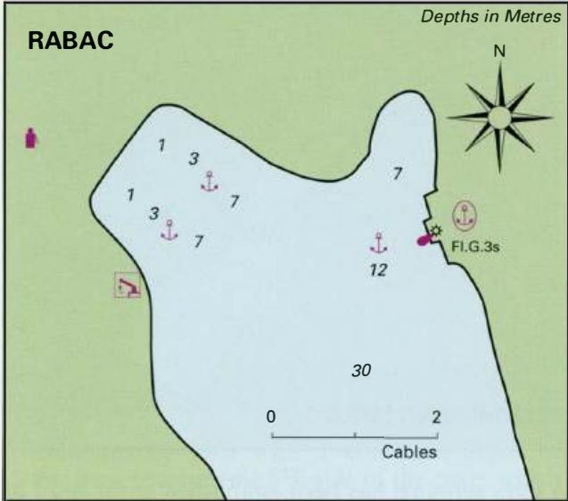
There are a number of possibilities for berthing or anchoring within the inlet. l. Uva/a Tunarica lies on the E side of Zaljev Rafa 2.8M from the entrance. Anchor in the N arm of the bay in 4 to Sm (mud, good holding), or secure alongside the quay (2.4m) if space permits. 2. Traget (Trget) lies on the E side of Zaljev Rafa, approximately lM from the head of the inlet. Anchor and take lines ashore among the local fishing boats on the NE coast of the inlet near the hamlet. There are two piers used by the fishing boats. If you wish to clear customs call at the harbourmaster's and customs' offices here. Rafa is a year-round port of entry, but, unless yeu have acceptable foreign currency or kuna, is not recommended for yachts because of the difficulties of getting money changed. In the hamlet is a cafe/bar. Facilities are limited to a cafe/bar and a campsite (where it is possible to obtain water). The nearest shop is over a mile away, up a steep hill. Luka Vinjole 44"55"1N 14"01"9E Charts BA 2719, 202, MK 4, lmray M24 Luka Vinjole is a wooded bay lying approximately 2M southwest of the entrance to Zaljev Rafa, and 1.4M northeast of the light on Hrid Seka. The inlet divides itself into two arms. There is a dangerous rock which only has depths of 0.3m over it lying in the centre of the bay (see plan). It is possible to anchor in either the N or the W arm, but the N arm offers better shelter in a bora. Anchor in 4-lOm (sand, good holding), and if required take a line ashore. Shelter in the bay is good from all but SE and S winds, although the bora blows strongly here. 3. Anchor in 8 to 15m (mud) at the head of Uvala Teplica or Uvala Sebesnica, taking lines ashore to the bollards.
Shelter
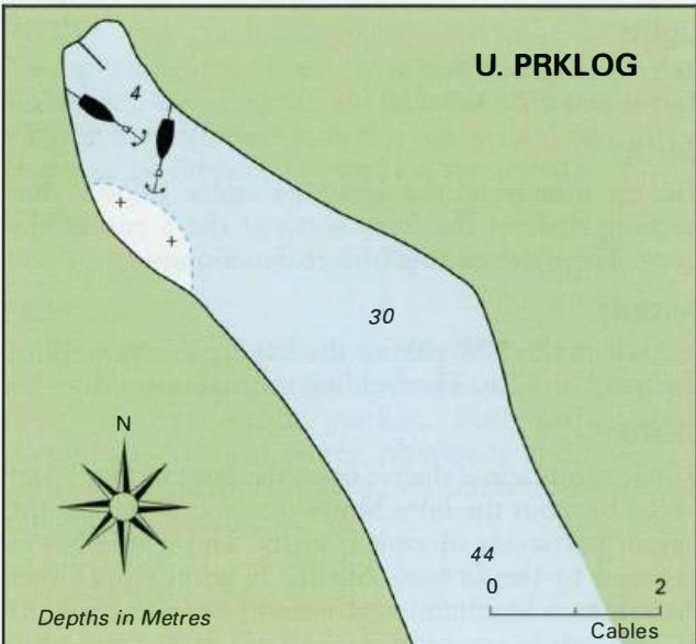
All-round shelter is available in Zaljev Rafa. The bora blows in very strong gusts in the inlet, and in these conditions it is best to be in Uvala Tunarica where its effect is not felt so strongly. LUKA KRNICA 44"57"N 14"02".3E Charts BA 1426 (plan), 2719, 202, MK 4, lmray M24 Luka Krnica lies immediately to the W of the entrance to Zaljev Rafa. It provides a pleasant overnight anchorage, avoiding a long trek up Zaljev Rafa. Shelter in the inlet is good from all but SE winds. There are no dangers in the approach to Luka Krnica. For details of the lights in the area see the above entry for Zaljev Rafa. There are no navigational lights within Luka Krnica. Anchor at the head of the inlet in 6-9m, as indicated on the plan. The bottom is hard mud and the holding is good. The quay is reserved for fishing boats. Off the quay and to the NE of it are a number of moorings. Note that there is a shallow area with depths of less than a metre extending from the opposite shore SE of the quay. Luka Budava
Adriatic Navigation Guide Images for ZALJEV RASA
Adriatic Navigation Guide images and captions provide additional visual reference for this navigation location.