Vrulje
Region: Central Adriatic
| Position: 43.81, 15.308333 | Adriatic Sea / Jadransko more
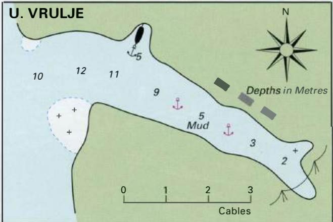
43°48'-6N 15°18'-5E Charts BA 277 7, SC 5767, MK 74, lmray M25 Vrulje is a small settlement on an inlet midway along the southwest-facing coast of Otok Komar. Its name comes from the presence of an underwater spring in the W part of the bay. The inlet offers good shelter from NW through N to SW. In W winds the off-lying islands provide some shelter
General
43°48'-6N 15°18'-5E Charts BA 277 7, SC 5767, MK 74, lmray M25 Vrulje is a small settlement on an inlet midway along the southwest-facing coast of Otok Komar. Its name comes from the presence of an underwater spring in the W part of the bay. The inlet offers good shelter from NW through N to SW. In W winds the off-lying islands provide some shelter from the seas. The approach to Vrulje is straightforward with no dangers in the immediate approach except for a rock close inshore near the S headland. The bay can be recognised by the small village consisting mainly of single-storey dwellings with small piers in front of them. There is a hostel on the N side of the bay, which has its own jetty. One of the Kornati National Park reception areas is located at Vrulje. Ashore there are two restaurants, a shop and a telephone. Anchor in approximately 4m, taking lines ashore if there are strong winds with any E in them or pick up one of the buoys provided for visitors. This is an extremely popular anchorage. If it is full it is possible to anchor in Uvala Modri Bok, the next bay NW of Vrulje. Anchor in depths of 7 to lOm on a bottom of sand (good holding). There are rocks in the E corner and just off the NW shore. Good shelter from NW through N to SE. Uvala Modri Bok is not an official overnight anchorage, but it makes a good place to stop for a swim and lunch. The anchorage in Uvala Strifoa has a number of visitors' buoys laid between Otok Kornat and the off-lying island. The hamlet of Kravljacica can be seen in the background to the NW part of the bay offering the best shelter in llm or less, and take lines ashore if necessary. Alternatively, pick up one of the buoys laid for visitors in U. Strifoja. The bottom is sand. There are two restaurants at Strizna, and another at Kravljacica, but no other facilities. Uvala Bele Lucice