Uvala Zavalatica
Region: South Adriatic
| Position: 42.911667, 16.94 | Adriatic Sea / Jadransko more
42°54".7N 16°56'.4E Charts BA 1574, SC 5767, MK 22, 23, lmray M26 There is a small harbour at Zavalatica, a village which is rapidly developing into a holiday centre. Zavalatica is situated 12M west of Rt Rafojic and 4M east of Rt Veli Zaglav (near Brna). There are major lights on both these headlands, but no navigational lights at Zavalatica. The
General
42°54".7N 16°56'.4E Charts BA 1574, SC 5767, MK 22, 23, lmray M26 There is a small harbour at Zavalatica, a village which is rapidly developing into a holiday centre. Zavalatica is situated 12M west of Rt Rafojic and 4M east of Rt Veli Zaglav (near Brna). There are major lights on both these headlands, but no navigational lights at Zavalatica.
Approach
The houses of the village and the new development of hotels on Dugi Rat, the headland to the E of the village, are conspicuous from seaward. There are no dangers in the approach, other than possibly fishing buoys.
Berth
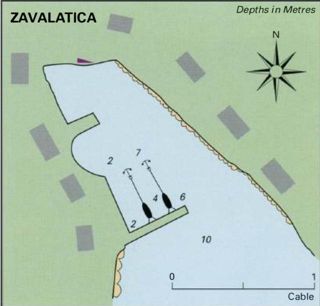
Go bow/stern-to the breakwater, on the inner side, as space permits. The bottom is sand and weed. There are a lot of moorings within the harbour area. Anchor Anchoring is not recommended.
Shelter
Good from W through N to E, but swell from winds with any S in them enters the harbour.
Facilities
Small supermarket, cafe/bar, restaurant, p1zzena, telephone, and postbox. Brna
Adriatic Navigation Guide Images for Uvala Zavalatica
Adriatic Navigation Guide images and captions provide additional visual reference for this navigation location.