Uvala Vrulje
Region: North Adriatic
| Position: 44.62, 14.25 | Adriatic Sea / Jadransko more
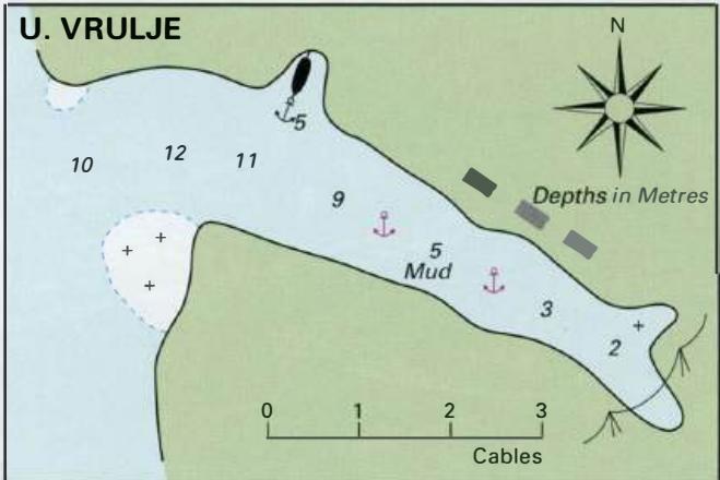
44°37'-2N 14°15'E Charts BA 202, MK 8, lmray M24 If caught in a bora whilst near the S part of Otok Unije it is possible to anchor close under the coast in Uvala Vrulje, 5 cables E of Rt Vnetak light. This bay does not provide shelter from any other direction. Uvala Vrulje also makes a pleasant lunchtime anchorage, with clean water for swimming. It
General
44°37'-2N 14°15'E Charts BA 202, MK 8, lmray M24 If caught in a bora whilst near the S part of Otok Unije it is possible to anchor close under the coast in Uvala Vrulje, 5 cables E of Rt Vnetak light. This bay does not provide shelter from any other direction. Uvala Vrulje also makes a pleasant lunchtime anchorage, with clean water for swimming. It is, however, too exposed to use as an overnight anchorage. Uva la Marafol on the east coast of Otok Unije has moorings laid for visitors. A track leads from the quay over the hill to the village on the other side of the island
Pilotage
See overview plan for Slovenia on page 298. Portoroz