Uvala Sveti Ivan (Uvala Gradina)
Region: South Adriatic
| Position: 42.971667, 16.678333 | Adriatic Sea / Jadransko more
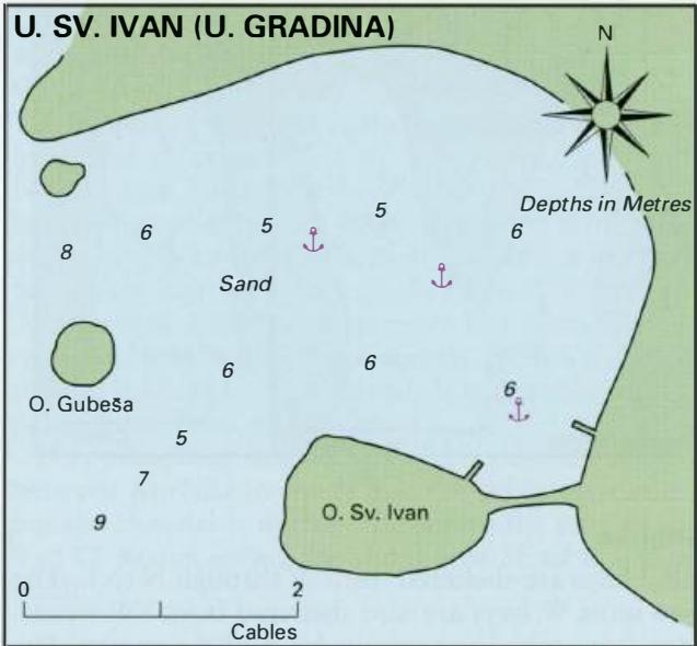
42°58'.3N 16°40"7E Charts BA 2772, 269 (detailed), SC 5767, MK 27, lmray M26 There is a good anchorage in the bay to the N of Otocic Sveti Ivan on the N shore of Zaljev Vela Luka. OtoCic Sveti Ivan is joined to Korcula by a narrow causeway. The anchorage is located E of 0. Kamenjak with its light. The chapel on 0. Sv. Ivan helps identify the anchor
General
42°58'.3N 16°40"7E Charts BA 2772, 269 (detailed), SC 5767, MK 27, lmray M26 There is a good anchorage in the bay to the N of Otocic Sveti Ivan on the N shore of Zaljev Vela Luka. OtoCic Sveti Ivan is joined to Korcula by a narrow causeway.
Approach
The anchorage is located E of 0. Kamenjak with its light. The chapel on 0. Sv. Ivan helps identify the anchorage. Pass either side of 0. Gube5a the island NW of 0. Sv. Ivan, although the deeper passage lies to the N. Anchor Anchor in 6m, sand. Good holding.
Shelter
The anchorage is sheltered from N through E to SE, but exposed to W and SW winds. The afternoon sea breeze sends a swell into the anchorage.
Facilities
None. Uvala Prihonja
Adriatic Navigation Guide Images for Uvala Sveti Ivan (Uvala Gradina)
Adriatic Navigation Guide images and captions provide additional visual reference for this navigation location.