Uvala Sv. Kristofor and the nearby inlets
Region: North Adriatic
| Position: 44.76, 14.703333 | Adriatic Sea / Jadransko more
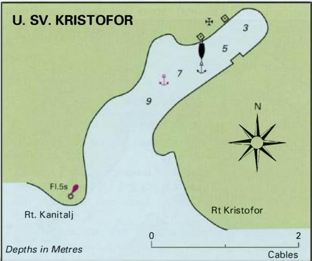
44°45'.6N 14°42'.2E Charts BA 202, MK 7, lmray M25, M24 Three adjacent inlets near Rt Sv. Kristofor provide sheltered anchorages on the W coast of Otok Rab. The two inlets to the E, Uvala Cifnata and Uvala Gozinka, are not named on the British Admiralty chart. The easternmost inlet, Uvala GoZinka, has a restaurant at its head, which helps identify
General
44°45'.6N 14°42'.2E Charts BA 202, MK 7, lmray M25, M24 Three adjacent inlets near Rt Sv. Kristofor provide sheltered anchorages on the W coast of Otok Rab. The two inlets to the E, Uvala Cifnata and Uvala Gozinka, are not named on the British Admiralty chart. The easternmost inlet, Uvala GoZinka, has a restaurant at its head, which helps identify it. Note that a shallow spit extends S from the headland lying between it and the middle inlet. Uvala Sv. Kristofor can be identified by the light structure on Rt Kanitalj, the headland to the W. The three inlets provide good shelter from all but S and SW winds. The holding in sand and weed is good. There are bollards around Uvala Sv. Kristofor for taking shore lines in a hara. This inlet is in fact the best.
Lights
Rt Kanitalj Fl.5s10m8M Uvala Sv. Mara
Adriatic Navigation Guide Images for Uvala Sv. Kristofor and the nearby inlets
Adriatic Navigation Guide images and captions provide additional visual reference for this navigation location.