Uvala Stracinska
Region: Central Adriatic
| Position: 43.336667, 16.37 | Adriatic Sea / Jadransko more
43°20'.2N 16°22'.2E Charts BA 2712, SC 5767, MK 76, lmray M26 Uvala StraCinska is a deep inlet on the south coast of Otok Solta rnM west of the light on Rt Livka Uvala Stracinska, on the south coast of Otok Solta, is sheltered from all but southerly winds Fl(2)5sl lm8M. The inlet has a number of bays at its head. A fish farm has been set up in the
General
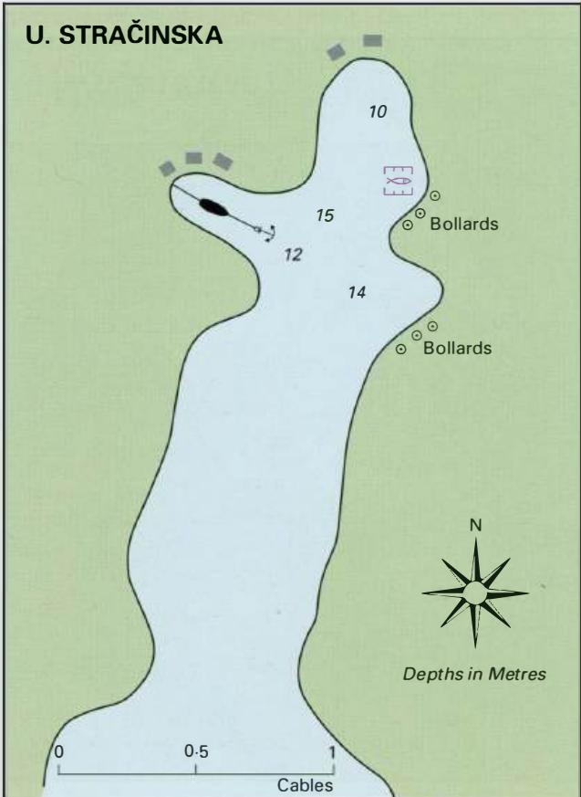
43°20'.2N 16°22'.2E Charts BA 2712, SC 5767, MK 76, lmray M26 Uvala StraCinska is a deep inlet on the south coast of Otok Solta rnM west of the light on Rt Livka Uvala Stracinska, on the south coast of Otok Solta, is sheltered from all but southerly winds Fl(2)5sl lm8M. The inlet has a number of bays at its head. A fish farm has been set up in the N part of the bay. There are bollards around these bays. Anchor in 10-15m and take lines ashore. This inlet is a good haven in a bora or a sirocco, and is sheltered from all wind directions except S. There are a few holiday homes around the shores of the inlet at its head, but no facilities. Uvala Tatinja