Uvala Stari Trogir
Region: Central Adriatic
| Position: 43.486667, 16.045 | Adriatic Sea / Jadransko more
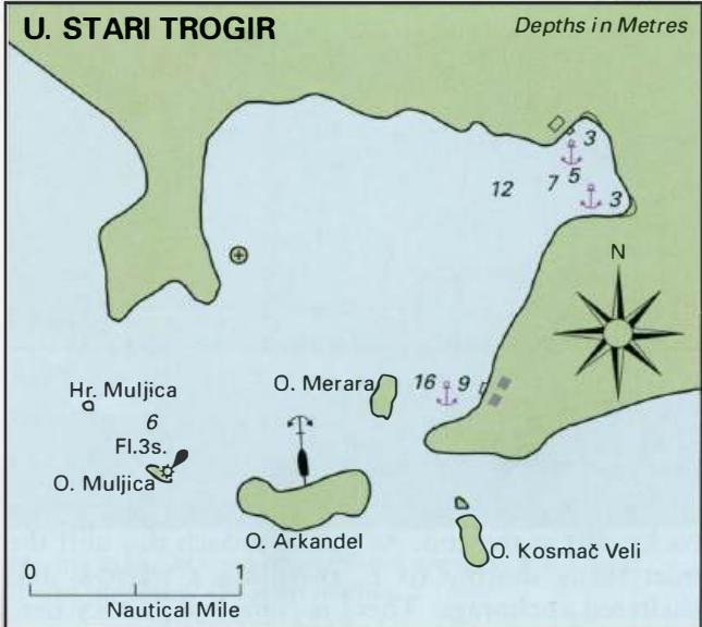
43°29'.2N 16°02'.7E Charts BA 2774, SC 5767, SC 5767, MK 76, lmray M26 Uvala Stari Trogir is a large bay protected from S by a number of islands. There is a quiet and sheltered anchorage in the NE corner, surrounded by hillsides, which show the traces of abandoned terracing. It is possible to enter Uvala Stari Trogir by any of the passages between
General
43°29'.2N 16°02'.7E Charts BA 2774, SC 5767, SC 5767, MK 76, lmray M26 Uvala Stari Trogir is a large bay protected from S by a number of islands. There is a quiet and sheltered anchorage in the NE corner, surrounded by hillsides, which show the traces of abandoned terracing. It is possible to enter Uvala Stari Trogir by any of the passages between the islands or the islands and mainland, but the best channel is close either side of 0. Muljica. There is a light on 0. Muljica Fl.3s15m5M. Beware of Hrid Muljica, which is situated 5 cables NW of the light structure. Approaching from NW beware of the low rock off Rt Ploea, which can be difficult to see, and 0. Melevrin, a rocky islet approximately 6 cables ESE of Rt Ploca. Within Uvala Stari Trogir there is a rock 1 cable offshore on the W side of the bay. The best anchorage for a yacht is in the NE or SE corner of the bay, as indicated on the plan. Anchor in a suitable depth, and take lines ashore in a bora. The bottom is sand and weed and the holding is good. Note that in some places there are patches of rock. The shelter is good from W through Uvala Sicenica
Adriatic Navigation Guide Images for Uvala Stari Trogir
Adriatic Navigation Guide images and captions provide additional visual reference for this navigation location.