Uvala Soline
Region: Central Adriatic
| Position: 43.925, 15.366667 | Adriatic Sea / Jadransko more
43°55'.5N 15°22'E Charts BA 271 1, SC 5767, MK 14, lmray M25 Uvala Soline is the best anchorage on Otok Pasman, being sheltered from all wind directions and totally unspoilt. The bay lies on the southwest coast of Otok Pasman approximately 3M northwest of the light on 0. Ko5ara. Approaching from NW the bay can be located by identifying the chapel o
General
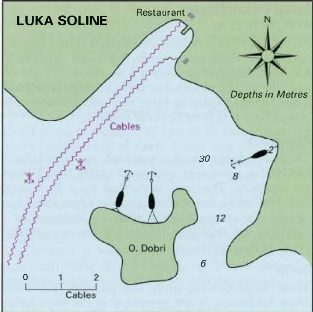
43°55'.5N 15°22'E Charts BA 271 1, SC 5767, MK 14, lmray M25 Uvala Soline is the best anchorage on Otok Pasman, being sheltered from all wind directions and totally unspoilt. The bay lies on the southwest coast of Otok Pasman approximately 3M northwest of the light on 0. Ko5ara. Approaching from NW the bay can be located by identifying the chapel on the shores of the next bay to the N, Uvala Sv. Ante. There are no dangers in the immediate approach to the anchorage. The S part of Uva la Soline enjoys allround shelter, and the holding in sand and weed is good. Depths in the S part of the bay range from 5 to 16m. Take lines ashore in a bora for added security. This is one of the designated anchorages. Irrespective of whether a mooring is used or the yacht's own ground tackle, a mooring fee (based on the length of the yacht} and a visitor's tax (levied on each visitor) are collected by an official boatman. The central part of the bay near the entrance has a rocky bottom, and is not recommended as an anchorage. Uvala Sv. Ante
Adriatic Navigation Guide Images for Uvala Soline
Adriatic Navigation Guide images and captions provide additional visual reference for this navigation location.