Uvala Prihonja
Region: South Adriatic
| Position: 42.988333, 16.703333 | Adriatic Sea / Jadransko more
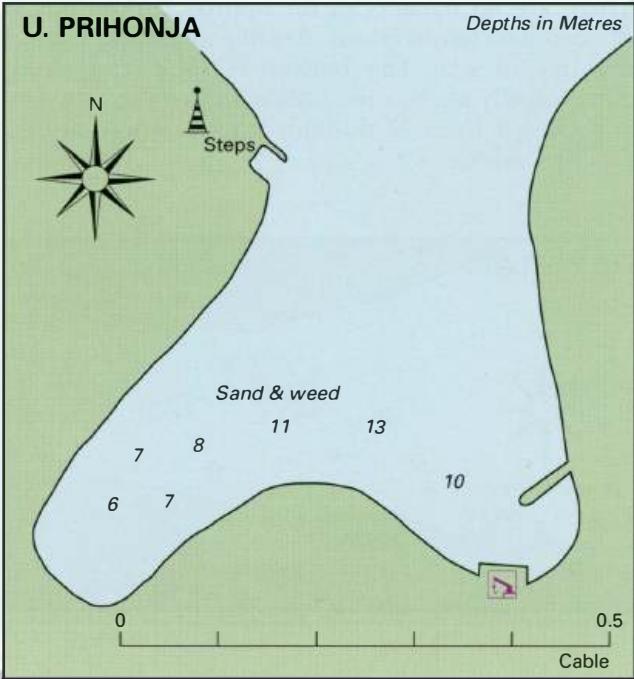
42°59"3N 16°42"2E Charts BA 2772, SC 5767, MK 27, lmray M26 U. PRIHONJA Depths in Metres Sand & weed 6 7 0 0.5 Cable Uvala Prihonja lies on the side of Otok Koreula 4M from Rt Proizd and SM from Uvala Prigradica. It is a quiet anchorage. There is a harbour at Prigradica and a small village where it is possible to find shelter from W through S to SE
General
42°59"3N 16°42"2E Charts BA 2772, SC 5767, MK 27, lmray M26 U. PRIHONJA Depths in Metres Sand & weed 6 7 0 0.5 Cable Uvala Prihonja lies on the side of Otok Koreula 4M from Rt Proizd and SM from Uvala Prigradica. It is a quiet anchorage. There is a harbour at Prigradica and a small village where it is possible to find shelter from W through S to SE. The harbour does however tend to be uncomfortable in the NW afternoon breeze.
Approach
The bay is easily identified by the pyramid-shaped beacon on the W headland, painted with red and white horizontal bands, and the 'no anchoring' symbol in Uvala Prapratna, the next bay W. There are no dangers in the immediate approach. Anchor Anchor in the SW arm of the bay m 7-8m. The bottom is sand and weed. Coming from W there are no off-lying dangers. From N beware of OtoCic PloCica, with a dangerous rock off its SE end, nearly 4M to the N. 2.4M east of Prigradica beware of Hrid Blaca, a rock lying 2 cables offshore and marked by an unlit beacon. Extending nearly lM to the E of Prigradica, and parallel to the shore, there is a low-lying group of rocks, Hridi Naplovci. Approaching from E, pass to the N of Hridi Naplovci. There is an unlit beacon, painted with red and white horizontal bands, on the westernmost islet.
Shelter
Good shelter from the NW afternoon breeze (but a swell enters in strong NW winds) through S to E. The bay is open N and NE. The harbour is sheltered from W through S to SE. It is exposed to the bora. Good shelter from NW through W to E. The harbour is very uncomfortable in strong N or NE winds,
Facilities
None. Uvala Prapratna 42"59".2N 16"42".6E Charts BA 2772, SC 5767, MK 27, lmray M26 Uvala Prapratna, the next bay E from Uvala Prihonja, is unsuitable for anchoring because an electricity cable comes ashore here. The bay is easily identified by the 'no anchoring' symbols and the pylons running up the hill from the head of the bay. Uvala Bristva 42"58"N 16"47"-3E Charts BA 2772, 1574, SC 5767, lmray M26 Uvala Bristva is no longer a suitable yacht anchorage. The bay has been taken over by a shipyard. The large gantry crane with RADEZ BLATO written on it is conspicuous from some distance. The white beacon on the headland to the W also helps identify the cove. Uvala Prigradica 42"58"N 16"48".8E Charts BA 2772, 1574, SC 5767, MK 27, 22, lmray M26 Cafe/bar open in the summer only. Restaurant. Small supermarket. Telephone. The harbour of Prigradica on the north coast of Otok Korcula One grocery shop only. Medical post (ambulanta), Post Office, telephone. Hotel and restaurant. Cafe/bar. Bistro. Bus service to Korcula. Uvala Kneza
Lights
Otocic Plocica Fl(2)10s25mlOM Prigradica breakwater Fl.R.3s6m3M
Berth
Go bow/stern-to the quay or breakwater. Anchor Anchoring is not permitted in the S part of the harbour, and most of the remaining part of the harbour is too deep for anchoring.
Adriatic Navigation Guide Images for Uvala Prihonja
Adriatic Navigation Guide images and captions provide additional visual reference for this navigation location.