Uvala Necujam
Region: Central Adriatic
| Position: 43.388333, 16.321667 | Adriatic Sea / Jadransko more
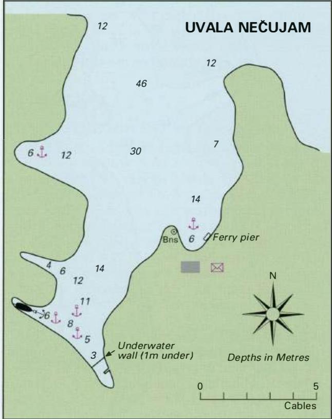
43°23'.3N 16°19'.3E Charts BA 2712, SC 5767, MK 16, lmray M26 Uvala Neeujam is a deep inlet, penetrating lM into the island, situated 8 cables SE of Rt Bad. There are a number of bays within this inlet offering shelter in most conditions, although shelter from N and NE is limited. It can be difficult finding space to anchor, especially at the heigh
General
43°23'.3N 16°19'.3E Charts BA 2712, SC 5767, MK 16, lmray M26 Uvala Neeujam is a deep inlet, penetrating lM into the island, situated 8 cables SE of Rt Bad. There are a number of bays within this inlet offering shelter in most conditions, although shelter from N and NE is limited. It can be difficult finding space to anchor, especially at the height of the season. The southernmost bay has a submerged wall stretching across it. In parts of the anchorage the bottom is soft mud and the holding consequently unreliable. Facilities at Necujam are limited to those provided by the hotel complex. These include water from the taps on the beach showers, a restaurant, cafe, bar and a supermarket. Bakers. Post Office and telephone. Neeujam was inhabited during Roman times, and there are some ruined Roman walls on the E side of the bay. There is also a ruined Gothic chapel. Stomorska