Uvala Majiska/Uvala Kolorat
Region: North Adriatic
| Position: 44.65, 14.51 | Adriatic Sea / Jadransko more
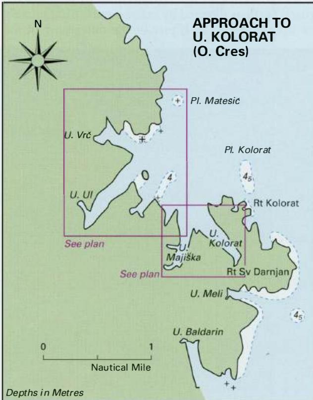
Uvala Vrc 44°39'N 14°30"6E Uvala UI 44°38"5N 14°30'.5E Uvala Kolorat/Uvala Majiska 44°38"4N 14°31 "7E Charts BA 202, MK 8, Im ray M24 At the far SE end of Otok Cres, nearly 3M southwest of the island of Trstenik, is a large bay, entered between Rt Kolorat and a headland approximately lM northwest, which is indented with a number of inlets. These in
General
Uvala Vrc 44°39'N 14°30"6E Uvala UI 44°38"5N 14°30'.5E Uvala Kolorat/Uvala Majiska 44°38"4N 14°31 "7E Charts BA 202, MK 8, Im ray M24 At the far SE end of Otok Cres, nearly 3M southwest of the island of Trstenik, is a large bay, entered between Rt Kolorat and a headland approximately lM northwest, which is indented with a number of inlets. These inlets provide pleasant and sheltered anchorages. From N these are called Uvala Vrc, Uvala Ul, and Uvala Majiska/Uvala Kolorat. These are some of the most peaceful and attractive bays and we have seen deer on the shores.
Approach
There are a number of dangers lying in the approaches to this bay, and within the bay itself. From N to S the dangers are as follows: Otok Cres -Luka JadrisCica
Berth
1. Uvala Vrc A deserted bay offering all-round shelter to vessels drawing less than 2m in the shallow N arm. ote the rocky ledge, which fringes the N side of the entrance as shown on the plan. Deep-draught yachts can anchor in the centre of the inlet, but this area does not enjoy allround shelter (sheltered from N through W to S). Luka Jadriscica (Pogana)
Adriatic Navigation Guide Images for Uvala Majiska/Uvala Kolorat
Adriatic Navigation Guide images and captions provide additional visual reference for this navigation location.