Uvala Lupeska
Region: South Adriatic
| Position: 42.77, 17.768333 | Adriatic Sea / Jadransko more
42°46'.2N 17°46'.1E Charts BA 1580, SC 5767. MK 25. lmray M26 Mainland Vratnik Otok Olipa Fl(3)10s Rt Lumpar Velika Vratnik Rt Seka Otok Jakljan Rt. Vratnik (Rt Lumpar) Approach to Mali Vratnik and Velika Vratnik from SW Distant 3 Miles Uvala Lupdka is a bay at the extreme SE of the Peljefac peninsula, which is protected to the SE by 0. Olipa. It i
General
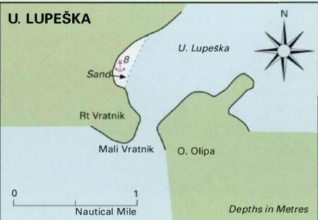
42°46'.2N 17°46'.1E Charts BA 1580, SC 5767. MK 25. lmray M26 Mainland Vratnik Otok Olipa Fl(3)10s Rt Lumpar Velika Vratnik Rt Seka Otok Jakljan Rt. Vratnik (Rt Lumpar) Approach to Mali Vratnik and Velika Vratnik from SW Distant 3 Miles Uvala Lupdka is a bay at the extreme SE of the Peljefac peninsula, which is protected to the SE by 0. Olipa. It is a quiet anchorage with exceptionally clear and clean water, ideal for bathing when there is no current running.
Approach
The anchorage can be entered from the NE from the direction of the Stonski Kanai, or from the SW passing through Mali Vratnik (between Rt Vratnik and 0. Olipa). There are no dangers in the approach. Anchor Anchor in 5 to Sm on the W side of the bay. The bottom is sand and good holding. Alternatively, anchor and take a line ashore.
Shelter
The anchorage is open NE, but well sheltered from other directions.
Facilities
None. THE ELAPHITE ISLANDS Charts BA 1580, SC 5767. MK 25, 26. lmray M26 The islands lying off the coast between Dubrovnik and the Peljesac peninsula are known as the Elaphite Islands, from the Greek word elafos meaning deer. Presumably, there were once many deer on the islands, but today there are none. The main islands in the group are Daksa, Kolocep, Lopud, Ruda, Sipan, Jakljan, Crkvina, Tajan, Olipa and, farther offshore, Sveti Andrija. There are a number of sheltered anchorages amongst these islands, and some attractive villages. OTOK KOLOCEP Kolocep is also known locally as Kalamota. The wooded island of Kolocep lies W of Gruz, and has two bays, which provide pleasant anchorages. There is a settlement on the shores of each bay. The main village is at Donje Celo on the N side of the island, and the smaller settlement is at Gornje Celo on the E coast. From the 14th to the 18th century, coral fishing was a major source of income. Besides the Adriatic, the divers of Kolocep went as far afield as the Aegean and Malta in their search for coral. The coral was sold by Dubrovnik merchants in the Levant, Italy and France. The island was fortified in the 16th century after repeated attacks by pirates, and some of the fortifications still exist. There are a number of churches and chapels on the island, as well as watchtowers, and a park financed by a local man, Pasko Barburica, who made his fortune trading saltpetre in Chile. It is possible to walk across the island, along a path joining the two settlements. Donje Celo
Adriatic Navigation Guide Images for Uvala Lupeska
Adriatic Navigation Guide images and captions provide additional visual reference for this navigation location.