Uvala Krtole
Region: South Adriatic
| Position: 42.396667, 18.708333 | Adriatic Sea / Jadransko more
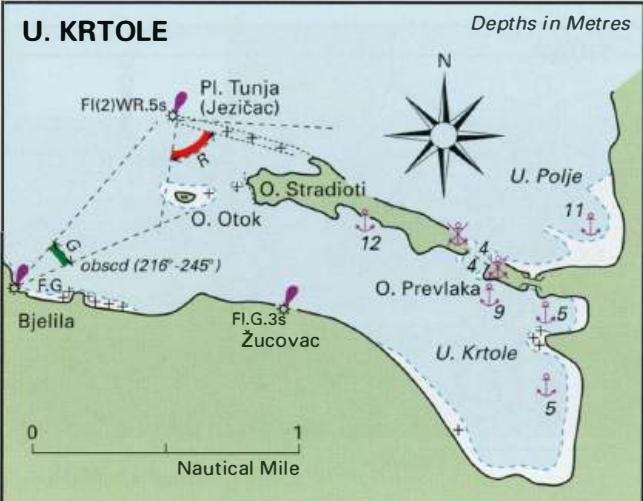
42°23'.8N 18°42'.5E Charts BA 1582, MK27 A sheltered anchorage is to be found in Uvala Krtole in the SE corner of Tivatski Zaljev. It is protected from NE and N (and to some extent from NW) by the islands of 0. Stradioti and 0. Prevlaka, and from the W through S to NE by the mainland. 0. Stradioti, also called Sveti Marko, is the site of a holiday
General
42°23'.8N 18°42'.5E Charts BA 1582, MK27 A sheltered anchorage is to be found in Uvala Krtole in the SE corner of Tivatski Zaljev. It is protected from NE and N (and to some extent from NW) by the islands of 0. Stradioti and 0. Prevlaka, and from the W through S to NE by the mainland. 0. Stradioti, also called Sveti Marko, is the site of a holiday camp dotted with grass huts. 0. Prevlaka (or Ostrvo Cvijeca), the so-called 'Island of Flowers' is also a holiday island, offering rather more sophisticated accommodation: bungalows. To the W of 0. Stradioti is the small 0. Otok, which has a church and monastery. Tivar airport is nearby.
Approach
Coming from W the belfry on 0. Otok is conspicuous. Head for the belfry and pass to the S of the island into U. Krtole. Approaching from give the prohibited area around Tivar naval dockyard a good berth and head for the beacon on PL Tunja (Jezieac). Leave it at least a cable to port and steer 193° to avoid the shallow reef with 0.6m over it extending NW from 0. Otok. Do not change course into U. Krtole until beyond 0. Otok. There is also a passage with a depth of 4m into U. Krtole, passing between 0. Stradioti and 0. Prevlaka. If using this passage, note that there are shallow spits extending from both islands (see diagram).
Lights
Pl. Tunja (Jezieac) Fl(2)WR.5s8m6/4M 014°-W-274°-R 0140 is sectored to cover the shoals extending from 0. Stradioti and 0. Otok Bjelila pier F.G.6m2M is obscured over Pl.Tunja 216°-obscd-245° Donji Krasi6 pier head F.G.5m2M Zukovac pier Fl.G.3s7m2M 168°-vis-135° Anchor Anchor in a suitable depth in whatever pos1t10n affords the best shelter in the conditions. The bottom is mud and good holding. Note that there are rocks off the headland SE of 0. Prevlaka and in the bays near Bjelila. An alternative anchorage lies in Uvala Polje (U. Kukuljina) N of 0. Prevlaka and 0. Stradioti.
Shelter
In various parts of the bay good shelter can be obtained from all directions with the exception of strong NW winds. Tivat
Adriatic Navigation Guide Images for Uvala Krtole
Adriatic Navigation Guide images and captions provide additional visual reference for this navigation location.