Uvala Krknjas
Region: Central Adriatic
| Position: 43.438333, 16.176667 | Adriatic Sea / Jadransko more
43°26'.3N 16°10'.6E Charts BA 2772, 2774, SC 5767, MK 16, lmray M26 There is a delightful anchorage on the SE side of Otok Drvenik Veli in the shallow area between the main island and the two off-lying islands of 0. Krknjas Mali and 0. Krknjas Veli. It is an ideal place to spend the day swimming, but should only be used as an overnight anchorage in
General
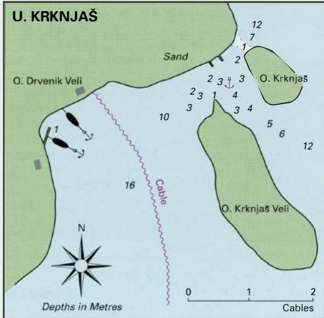
43°26'.3N 16°10'.6E Charts BA 2772, 2774, SC 5767, MK 16, lmray M26 There is a delightful anchorage on the SE side of Otok Drvenik Veli in the shallow area between the main island and the two off-lying islands of 0. Krknjas Mali and 0. Krknjas Veli. It is an ideal place to spend the day swimming, but should only be used as an overnight anchorage in settled weather, and after checking that the anchor is holding. There are a few houses and a restaurant amongst the trees, and occasionally tripper boats call here. The anchorage can be approached from S or SE, passing either side of 0. Krknjas Veli. The channel between 0. Drvenik Veli and 0. Krknjas Mali is shallow and rocky. Anchor in 3m in the bay formed by the three islands, or anchor and take a line ashore in the area shown on the plan but keep clear of the cable. The bottom is sand and weed with patches of rock. Be careful where you place your anchor and dig it in well. The holding is unreliable. The anchorage is sheltered from W through N to NE. Uvala Mala Luka
Adriatic Navigation Guide Images for Uvala Krknjas
Adriatic Navigation Guide images and captions provide additional visual reference for this navigation location.