Uvala Donja Krusica
Region: Central Adriatic
| Position: 43.41, 16.273333 | Adriatic Sea / Jadransko more
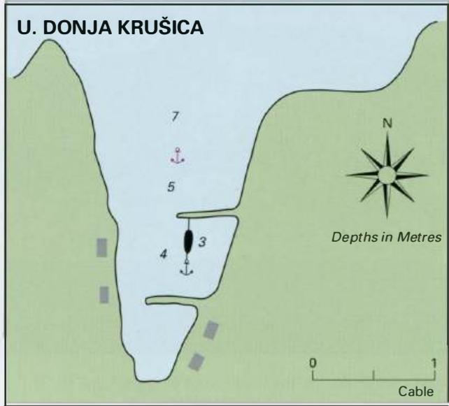
43°24'.6N 16°16"4E Charts BA 2712, SC 5767, MK 16, lmray M26 There is a small harbour offering shelter to smaller yachts at Donja Krusica on the N coast of Otok Solta, just E of the headland, Rt Grcki. The harbour is 1.8M west of the light on Rt Bad near Rogac. The approach is clear of dangers. Berth among the small local boats inside the outer har
General
43°24'.6N 16°16"4E Charts BA 2712, SC 5767, MK 16, lmray M26 There is a small harbour offering shelter to smaller yachts at Donja Krusica on the N coast of Otok Solta, just E of the headland, Rt Grcki. The harbour is 1.8M west of the light on Rt Bad near Rogac. The approach is clear of dangers. Berth among the small local boats inside the outer harbour wall. The harbour is exposed to N and NW winds, but is sheltered from other directions. There are a few holiday homes here, but no facilities. OTOK DRVENIK VELI Charts BA 2712, 2774, SC 5767, MK 76, lmray M26 Otok Drvenik Veli is an island approximately 3M long by 2M wide lying 2M northwest of Otok Solta. The island has a small population of farmers and fishermen, most of whom live in the village called Drvenik. Drvenik