Uvala Borovica
Region: Central Adriatic
| Position: 43.503333, 15.99 | Adriatic Sea / Jadransko more
43°30'-2N 15°59'-4E Charts BA 2774, SC 5767, MK 16, lmray M25 Uvala Borovica is a narrow inlet running N-S with a rocky cliff at the end. As you approach this cliff the inlet turns sharply to E, revealing a narrow and sheltered anchorage. There is complete privacy here and good shelter from W through N to E. If the wind starts to pick up from S, SE
General
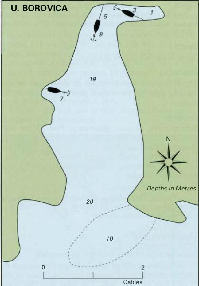
43°30'-2N 15°59'-4E Charts BA 2774, SC 5767, MK 16, lmray M25 Uvala Borovica is a narrow inlet running N-S with a rocky cliff at the end. As you approach this cliff the inlet turns sharply to E, revealing a narrow and sheltered anchorage. There is complete privacy here and good shelter from W through N to E. If the wind starts to pick up from S, SE or SW it is advisable to leave and proceed to Rogoznica. With strong winds and the accompanying swell from S, SE or SW it is difficult, if not dangerous, trying to leave this inlet because it is so narrow. Uvala Borovica lies 8 cables NE of Rt Ploea and 5 cables of the small islet, 0. Melevrin. It is easily located by the small white chapel on Rt Ploca, which shows up well. When approaching keep a good distance off Rt Ploca because of the low off-lying rock on which there is green light beacon. At the entrance to Uvala Borovica there is a patch with lOm over it (see plan), but depths beyond this in the inlet are considerably deeper until the far end is reached. Anchor and take a line ashore. Luka Rogoznica Charts BA 2774, SC 5767, MK15, 16, lmray M25 Luka Rogoznica is a large enclosed bay approximately 4YzM southeast of Primosten. In the centre of the bay is the island on which the village of Rogoznica is built. Excellent shelter from all wind directions and from swell can be found in various parts of the bay. There are a number of anchoring and mooring possibilities within the bay. The most important anchorage and harbour is to the W of Rogoznica island itself, where an expensive marina has been built on the shore opposite the village, but it is also possible to anchor and take a line ashore to the E side of the island. To the S of Rogoznica village Marina Frapa in Luka Rogoznica is architecturally quite unlike any other Croatian marina there is an inlet and quay at Rafanj. The most N part of the bay has an anchorage in Uvala Stupin to the E, and a quay used by fishing boats at Uvala Soline to the W.
Approach
The approach to Luka Rogoznica requires care because of the various off-lying islands, rocks and shoals. Approaching from S it is possible in good weather to pass between Rt Movar on the mainland and Otok Smokvica Vela, keeping to the E of the light structure on the off-lying islet of Hrid Kalebinjak. From here steer N passing Rt Konj at a distance of 1 cable. Note the presence of a wreck, which should be avoided, further W of Rt Konj. The currents around Rt Konj can be strong. Once beyond Rt Konj turn into Luka Rogoznica. Alternatively, approach Rogoznica from S by passing to the W of Otok Smokvica Vela. Beware of an unmarked shoal, PliCina Smokvica with just Sm over it, which lies 4 cables NW of Otok Smokvica Vela. A shoal with a dangerous rock, over which the seas break, extends nearly 2 cables W of 0. Smokvica Mala (the small island N of Otok Smokvica Vela). The rock is marked by an unlit beacon. NE of 0. Smokvica Mala an unlit mooring buoy lies in the channel. Approaching from N entry into Luka Rogoznica is straightforward. Beware of Greben Grbavac, a rock marked by a lit beacon approximately 4 miles NW of the entrance, and PliCina Veli Brak, a shoal marked by an unlit buoy lM north of Hrid Mulo. The lighthouse and stone tower on Hrid Mulo are visible for some distance. Nearer to the entrance, beware of the dangers in the vicinity of Otok Smokvica Vela mentioned above.
Lights
Greben Grbavac Fl(2)5s7m7M Hrid Mulo Fl.5s23m21M Hrid Kalebinjak Fl(2)10s7m3M Rt. Gradina Fl.R.5s15m4M Rogoznica quay Fl.G.3s7m3M Marina Frapa breakwater Fl.R.3s6m3M
Adriatic Navigation Guide Images for Uvala Borovica
Adriatic Navigation Guide images and captions provide additional visual reference for this navigation location.