Uvala Bliznica
Region: Central Adriatic
| Position: 44.475, 15.138333 | Adriatic Sea / Jadransko more
44°28'.5N 15°08'.3E Charts BA 515, MK 70, lmray M25 Uvala Bliznica is another cove on the NE coast of the Velebitski Kanai, which offers good shelter in a hara. The bay is however extremely difficult to locate. It is easy enough to go past it without recognising it as we did first time round! The best way to locate Uvala Bliznica is by taking a bea
General
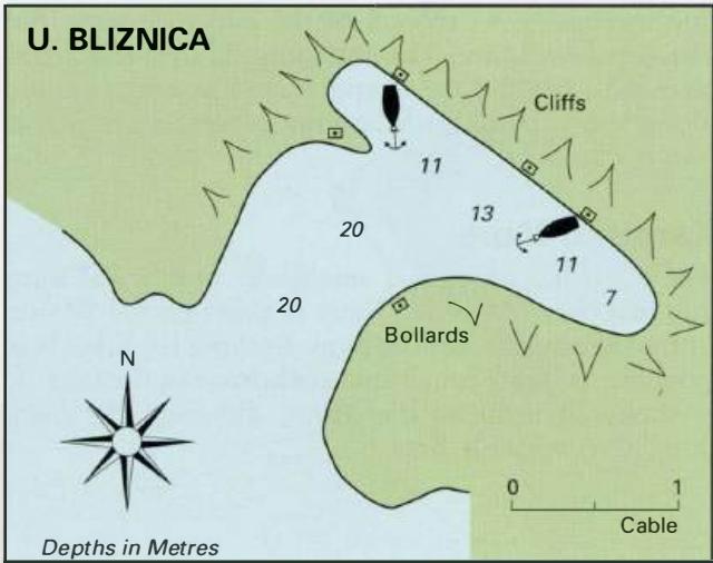
44°28'.5N 15°08'.3E Charts BA 515, MK 70, lmray M25 Uvala Bliznica is another cove on the NE coast of the Velebitski Kanai, which offers good shelter in a hara. The bay is however extremely difficult to locate. It is easy enough to go past it without recognising it as we did first time round! The best way to locate Uvala Bliznica is by taking a bearing on the light structure at Rt Kristofor, which is approximately 2.3M to the W. Approaching from S it is possible to see the Adriatic Highway some distance up the mountain side with a number of houses nearby. Some low rocks at the NW entrance to Uvala Bliznica can also be seen if close to the shore. Approaching from N a reddish-brown wedge-shaped cliff (with the steep side to the sea) lying to the SE of the bay and the low rocks at the NW side of the entrance help locate the bay. There is a conical shaped hill to the E of the haven. Within Uvala Bliznica are three bollards at the head of the inlet, and two others, one on each side of the inlet. Anchor in 1 lm towards the head of the bay and take lines to the bollards. There are no buildings here, and no facilities. 44°31'.5N 15°04'.6E Charts BA 575, 202, MK 70, lmray M25 Karlobag is a small holiday town and ferry port at the foot of the Velebit mountains on the NE side of the Velebitski Kanai. It has a small, open harbour, which offers limited shelter. Karlobag can however be a useful place to stop for supplies.
Approach
Karlobag lies approximately 3M north of Rt Kristofor. The town is conspicuous from seaward. On the headland on the S side of the town is a distinctive church belfry next to the ruined church, which helps identify the town positively. Approaching from S there are no dangers. Approaching from N beware of the various rocks and shoals which in places lie up to 3 cables off the mainland coast for the 3M northwest of Karlobag.
Lights
Rt Kristofor (Otok Pag) Fl.5s62m7M Rt Jurifoica (mainland coast) Fl(3)12s10m9M Karlobag S breakwater FLG.3s8m4M
Berth
There are three piers at Karlobag. The S pier or breakwater (on which the light is exhibited) has stone ballasting on both sides, which prevents yachts from tying up alongside. Some of the stone ballasting lies up to 15m from the end of the breakwater. The N side of the NW pier is used by the car ferry. The best berth for a yacht is to tie up alongside the central pier. Depths alongside this pier range from 3m to 2m. Karlobag, at the foot of the Velebit mountains, seen from south There is a deep cove to the E of the town where it is possible to anchor (in 12-18m), although it is essential to take lines ashore. On the SE side of the cove there is a quay with some bollards nearby.
Shelter
The cove offers slightly better shelter in a hara and in NW winds than does the harbour. In the cove shelter can be found from NW through N to E. The harbour offers only mediocre shelter from N and E winds.
Officials
Harbourmaster and police.
Facilities
No public water tap. Petrol and diesel from the filling station on the main road, a short walk up the hill to the NW of the harbour. Several supermarkets, butcher, baker, fruit and vegetable market. Bank, ATM, Post Office and telephones. Tourist information. Hotels, restaurants, cafe/bars. Bus service. Car ferry to Pag.
History
The original town, called Bag, was destroyed by the Turks in 1525. It was rebuilt in 1579 by the Hapsburg Archduke Charles (or Karl) and renamed Karlobag. In 1592 the Venetians destroyed the town and occupied the castle. The town only started to recover at the end of the 17th century, when another Archduke Karl commissioned the construction of the harbour. At about the same time a road was built over the Velebit mountains, which encouraged trade to pass through the harbour at Karlobag. Luka Cesarica
Adriatic Navigation Guide Images for Uvala Bliznica
Adriatic Navigation Guide images and captions provide additional visual reference for this navigation location.