Uvala Basina
Region: South Adriatic
| Position: 43.198333, 16.67 | Adriatic Sea / Jadransko more
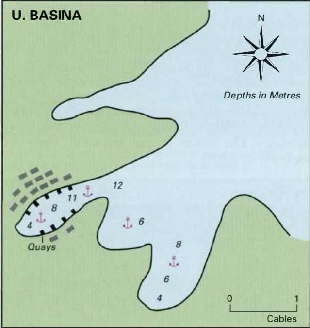
43°11'-9N 16°40'.2E Charts BA 2712, SC 5767, MK 19, lmray M26 Uvala Basina is located on the N coast of Otok Hvar, rnM WNW of the light on OtoCic Zecevo. The bay is divided into three parts. The W part has a number of houses and small quays around it, the other two parts of the bay are quieter and make suitable lunchtime anchorages. Approaching the
General
43°11'-9N 16°40'.2E Charts BA 2712, SC 5767, MK 19, lmray M26 Uvala Basina is located on the N coast of Otok Hvar, rnM WNW of the light on OtoCic Zecevo. The bay is divided into three parts. The W part has a number of houses and small quays around it, the other two parts of the bay are quieter and make suitable lunchtime anchorages. Approaching the bay, keep at least 2 cables offshore to avoid a shallow spit on the N of the bay, and a rock and a second shallow spit which lie to the SE. All of these dangers lie within lM of the entrance. Anchor in the section of the bay which appeals. Shelter can be obtained from N, through W to E. Uvala Maslinica
Adriatic Navigation Guide Images for Uvala Basina
Adriatic Navigation Guide images and captions provide additional visual reference for this navigation location.