Trogir
General
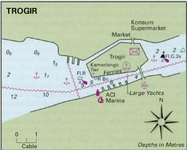
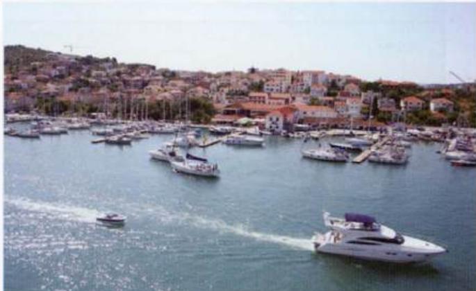
43°30'.9N 16°15"2E Charts BA 2772, 2774, SC 5767, MK 76, lmray M26 The old town of Trogir is built on a smaJl island between the mainland to the N and Otok Ciovo to the S. Although most of the walls, which once surrounded the town, have been knocked down there are still many medieval houses, churches and narrow streets to excite the imagination. There is an ACI marina opposite the old town, which unfortunately is overcrowded and cramped at the height of the season. The marina is closed to visiting yachts on Fridays, when charter yachts take up all available space. Space is also limited on Saturdays. Trogir is a convenient location for organising a crew change, since Split International Airport is located nearby.
Approach
The bridge joining Otok Ciovo to the mainland at Trogir no longer opens, and if you have an air draught of more than 2.4m it is therefore not possible to take this short cut between Kastelanski Zaljev and Trogirski Zaljev. The channel from the east is marked by red and green buoys and has a least depth of 4m. It is possible to anchor in this area to the E of Trogir, just N of the buoyed channel in 2m. Trogir is usually approached from the W, since both the marina and main town quay lie to the W of the bridge. From Rt Okruk NE there are no dangers in the approach until nearing Rt Cubrijans,_ whih hs a light. The mainland shore N of Rt CubrIJan is shallow, as is the area S of Rt Cubrijan itself. Keep to the centre of the channel up to Trogir. Note that there is a R light buoy to the N of the channel, W of the castle. Just S of the castle is an unlit R beacon on the N side of the channel. The channel has depths of ll m at the entrance and 4m near the bridge. On occasion, there can be a strong current (up to 3kn) flowing under the bridge. The current is normally W flowing.
Lights
Rt Okruk Fl.G.3s6m5M Heid Celice Fl(3)10s15m6M Rt Cubrijan Fl.G.2s8m4M There are no navigational lights at Trogir harbour or manna
Berth
Berth at the marina as directed. Alternatively, tie up alongside the town quay, avoiding the ferry berth. The town quay is in practice, however, reserved for yachts of 25m plus. Berths here can be reserved by contacting the Harbourmaster 'H' 021 881 508. Unfortunately the westernmost berths are subject to wash from passing powercraft. Anchoring in the channel E of a line between Rt Cubrijan and the pier at Seget is prohibited on account of an underwater cable. Yachts anchor W of the old town and the R light buoy, on the N side of the channel inside the Sm contour line. If approaching from the Kastelanski Zaljev, it is possible to anchor in 2m N of the buoyed channel E of the town.
Shelter
Good all-round shelter.
Officials
Harbourmaster. Police.
Facilities
Water, fuel and electricity at the marina. The fuel berth has depths of 3m alongside and is open between 0800 and 1900. The marina, which is open throughout the year, has toilets, showers, laundry, grocery shop, restaurant, slipway, 10-ton crane, workshop, and repair facilities for engines and hulls. Gas bottles can also be refilled (not on site). Water and electricity are available on the town quay. The town has several good supermarkets, bakers, and butchers. There is a large daily fruit and vegetable market, which is even open on Sunday mornings during the summer. The fish market is on the town quay. Hardware store. Banks and Post Office. ATMs. Telephones. Internet cafe (expensive) at the marina and another cheaper one in the old town. Medical centre and pharmacy. Tourist information office, hotels, restaurants and cafe/bars. ACI Marina at Trogir Bus service to Split. Car hire and taxis. At busy times it is better to get a taxi from the town, rather than the marina. Split international airport is nearby. The marina address is: ACJ Marina Trogir, 21220 Trogir, Croatia '2ir 021 881 544 Fax 021 881 258 Email [email protected]
History
The old town of Trogir stands on the foundations of the Greek colony of Tragurion, although there is evidence that this area was inhabited during the Stone Age. Under the Romans Trogir was an important port, but its importance declined with the growth of Salona on the eastern side of the Kastelanski Zaljev. When Salona was destroyed by the Slavs and the Avars in AD614 some of the inhabitants of Salona fled to Trogir. Trogir itself was almost completely destroyed by the Saracens in 1123, but despite this disaster was rebuilt. The town reached its greatest prosperity during the next two centuries. In 1420, after a siege lasting four days, Trogir was captured by Venetian forces and remained under Venetian rule until 1797. There are many medieval houses and churches in the town, as well as a town museum and the castle. The carved doorway at the cathedral, known as Radovan's Portal after its sculptor, is a lively and fascinating example of medieval sculpture. It was carved in 1240. Seget
Adriatic Navigation Guide Images for Trogir
Adriatic Navigation Guide images and captions provide additional visual reference for this navigation location.