Sutomorski (Spicanski) Zaljev
Region: South Adriatic
| Position: 42.135, 19.055 | Adriatic Sea / Jadransko more
42°08'.1N 19°03'.3E Charts BA 1582, MK 28, lmray M27 Three miles NW of Bar is the wide bay of Sutomorski (Spieanski) Zaljev. It is fringed by a sandy beach and has developed into a popular holiday area. The bay is open to S and SW. It is a suitable lunchtime anchorage in settled weather. The village of Sutomore lies at the head of the bay. The bay
General
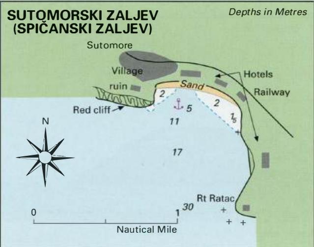
42°08'.1N 19°03'.3E Charts BA 1582, MK 28, lmray M27 Three miles NW of Bar is the wide bay of Sutomorski (Spieanski) Zaljev. It is fringed by a sandy beach and has developed into a popular holiday area. The bay is open to S and SW. It is a suitable lunchtime anchorage in settled weather. The village of Sutomore lies at the head of the bay.
Approach
The bay can be recognised by the red cliffs to the S of the village of Sutomore. If approaching from Bar, beware of rocks which extend for nearly 2 cables from Rt Ratac on the S side of the bay. Half a mile N of Rt Ratac more rocks lie close inshore. There are no navigational lights. Anchor Anchor m Sm, sand, good holding. Beware of bathers.
Shelter
The only shelter is from N and NE. The anchorage is exposed to wind and swell from all other directions.
Facilities
There are hotels and restaurants around the bay, and shops in the village of Sutomore. Uvala Canj
Adriatic Navigation Guide Images for Sutomorski (Spicanski) Zaljev
Adriatic Navigation Guide images and captions provide additional visual reference for this navigation location.