Sidriste Zalic (Luka Zalic)
Region: Central Adriatic
| Position: 44.373333, 14.696667 | Adriatic Sea / Jadransko more
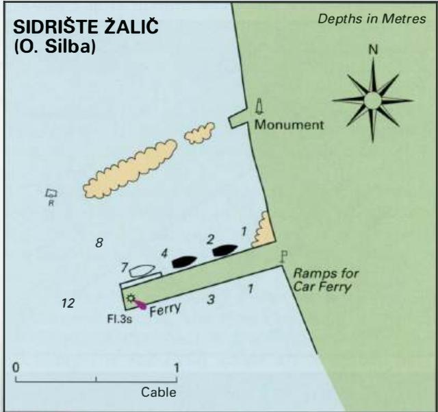
44°22'-4N 14°41'-8E Charts BA 575, MK 9, 77, lmray M25 Sidriste Zalic is the name of the bay on the W coast of Otok Silba. Within this bay near the village is a pier where it is possible to tie up alongside. Depths alongside range from 1m near its root to over 4m near its head. The ferry uses the end of the pier and the car ferry berths at the quay
General
44°22'-4N 14°41'-8E Charts BA 575, MK 9, 77, lmray M25 Sidriste Zalic is the name of the bay on the W coast of Otok Silba. Within this bay near the village is a pier where it is possible to tie up alongside. Depths alongside range from 1m near its root to over 4m near its head. The ferry uses the end of the pier and the car ferry berths at the quay on the S side of the pier. Shelter can be obtained from N through E to S here, although in strong S winds it would be preferable to be in Luka Silba on the E side of the island. The pier however offers a secure berth in a bora. Approaching the pier is straightforward, although beware of the submerged ruined pier lying just of the present pier. The W extremity of the ruined pier is marked by an unlit red buoy. The new pier has a white-painted metal light structure Fl.3s6m3M on its end. The facilities available here are the same as described for Luka Silba. Luka Papranica
Adriatic Navigation Guide Images for Sidriste Zalic (Luka Zalic)
Adriatic Navigation Guide images and captions provide additional visual reference for this navigation location.