Prcanj
General
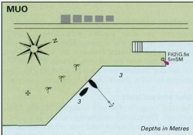
42°27'-2N 18°45'.3E Charts BA 1582, MK 27, lmray M27 Preanj is one of the many small settlements in the Boka Kotorska which has a quay where it is possible to tie up to explore the village or to stop for lunch. From the border with Montenegro to the border with Italy approximately 300 miles to the NW this is a fabulous cruising area, which attracts yachtsmen and holidaymakers from all over Europe. We have divided the coverage as far as Slovenia into four chapters. This chapter covers the area from the border with Montenegro to Podgora on the mainland, and includes the Pelje$ac peninsula, the anchorages in Zaljev Klek Neum (which belong to Bosnia-Herzegovina), and the off-lying islands from Lokrum in the S to Hvar in the NW, including Mljet, Korcula, Hvar, Lastovo and Vis. Restricted areas Otok Mljet The western third of Otok Ml jet has been designated a National Park, with regulations in force to protect the park. These regulations are a matter of common sense, for example, not leaving litter, lighting fires, or hunting. Ports or anchorages described in this pilot which fall within the ational Park are Kozarica, Polace and Pomena. Yachts are allowed to anchor or moor in these areas. Yachts are not, however, permitted to enter Zaljev Soline {the bay in the approach to Veliko Jezero), and nor are they allowed to enter Veliko Jezero.
Approach
Preanj lies 3 cables NW of Rt Rdakova, on the SW shores of the Kotorski Zaljev.
Lights
Rt Rdakovo Fl.G.5s8m6M Preanj quay Fl(2)G.6s7m6M
Berth
Tie up alongside the quay. The steeply shelving bottom and great depths make anchoring here impractical.
Shelter
The quay at Preanj is exposed, especially in N or NE winds.
Facilities
Several shops. Post Office. Restaurant. Bus service.
History
There are a number of fine buildings and churches at Preanj dating from its days of prosperity, when its sea captains built themselves handsome houses and were generous in their gifts to the Church. The town gave birth to a number of prominent sea captains, including Captain Ivan Visin who circumnavigated the world in 1852-9 in the schooner Splendido. The English poet Byron lived in Preanj for a while. 3.1 Croatia Molunat to Podgora
Local Weather Effects
During the summer months, the usual weather pattern encountered in this area tends to consist of flat calms or light winds in the mornings and a sea breeze setting in from midday. The sea breeze in this area is almost invariably a W to NW wind because of the E-W alignment of the islands. It can reach Force 4 or 5, or, if occurring with winds from the W quadrant, can increase the barometric gradient wind to Force 6 or 7 for a while. This W wind blowing against the normally west-going circulating current creates steep seas which make sailing to windward wet and uncomfortable. The sea breeze usually disappears at about 1800 {local time) leaving a sloppy sea which finally dies away at about midnight. Sailing should be timed to take advantage of these conditions. In the mornings, you will probably have to motor. In the afternoons, you will be able to sail to your destination, but if it lies to the W you will have a hard slog to windward. The mainland in the area covered by this chapter is mostly mountainous. The bora blows strongly throughout the area, but is particularly violent where valleys funnel the wind. The areas where the bora blows most violently are in Zaton Zuljana (on the S side of the Peljesac peninsula), near the mouth of the eretva river, and in Kanai Malog Stona. The Mljetski Kanai is also subject to strong NE winds, which fall off the mountains of the Peljefac peninsula, especially towards evening (katabatic winds). The sirocco is felt strongly in certain areas, notably off Orebic and Trpanj. Southerly winds raise a considerable sea off the south-facing coast of Mljet and off Orebic. West winds blow strongly in the Peljeski Kanai where they raise a big sea off Orebic. The Pakleni Kanai is another area where W winds blow strongly. Magnetic variation and anomalies
Adriatic Navigation Guide Images for Prcanj
Adriatic Navigation Guide images and captions provide additional visual reference for this navigation location.