Pomena
Region: South Adriatic
| Position: 42.788333, 17.348333 | Adriatic Sea / Jadransko more
42°47'-3N 17°20'.9E Charts BA 1580, SC 5767, MK 24, lmray 26 Pomena lies on the NW tip of Mljet. Of all the harbours and anchorages on Mljet it is the one most developed for tourism. There is a big hotel overlooking the bay; a campsite, tripper boats and a 'landscaped' quayside. It is possible to walk to the lakes of Mali Jezero and Veli Jezero fro
General
42°47'-3N 17°20'.9E Charts BA 1580, SC 5767, MK 24, lmray 26 Pomena lies on the NW tip of Mljet. Of all the harbours and anchorages on Mljet it is the one most developed for tourism. There is a big hotel overlooking the bay; a campsite, tripper boats and a 'landscaped' quayside. It is possible to walk to the lakes of Mali Jezero and Veli Jezero from Pomena, and to join a tripper boat that goes from Mali Most bridge to OtoCic Sv. Marija.
Approach
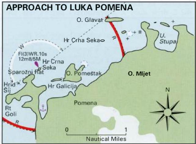
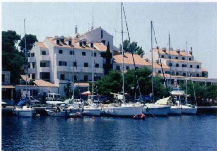
The approach to Luka Pomena requires care (see plan and diagram). Approaching from E or N beware of the rock only just under the surface NE of the small island at the entrance to Uvala Stupa. Identify Otok Glavat. It is possible to pass 0. Glavat on either side, but note that there are two islets lying S of it. Rocks extend between the eastern islet and Mljet, and to the S of this islet. The other islet should not be approached too closely. The large island now in front of you is called Otok Pome5tak. It has a shallow spit with less than 3m over it extending up to 2 cables from the NE corner. It is possible to pass midway between 0. Pomdtak and Mljet, but beware of a rocky spit extending from Mljet. There is 6.4m in the channel. Approaching Pomena from W, note that there is a rock and an islet (Hr. Sij), 2 cables NW of a point midway between Rt Goli and Sparofoi Rat (the N The public quay at Luka Pomena Approach to Pomena from Northeast Many yachts anchor and take lines ashore to 0. Pomestak, preferring this option to the quay at Pomena headland of this promontory). An islet lies NE of Sparofoi Rat. Pass either side of this islet to enter Luka Pomena and then steer to pass to the SW of Hr. Galicija, which is an islet W of the SW end of 0. Pomdtak (see plan). There are no navigational lights in this area.
Berth
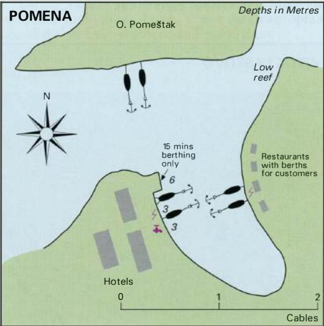
Moor bow/stern to the quay near the hotel, or bow/stern to the quay on the opposite side of the inlet at one of the restaurant quays. Anchor Anchor to the S of 0. Pomestak, taking a line ashore. It is also possible to anchor in the S part of the bay, to the W of Pomena. This is a sheltered and pleasant anchorage.
Shelter
Luka Pomena is reasonably well protected by the off-lying islands, and shelter from all directions can be obtained in various parts of the bay. Rt Struga lighthouse, built on the clifftops on the S coast of Otok Lastovo, is distinctive and helps locate the hidden harbour of Skrivena Luka
Facilities
There are hotels, restaurants and a cafe near the quay. It is possible to change foreign currency at the hotel, also to hire bicycles. Car hire is available. Water can be obtained at the campsite where there is a small shop. The campsite. is approximately 15 minutes' walk away. Electricity has been laid onto the hotel quay, and to the Yacht Parking Galija berths opposite. OTOK LASTOVO Charts BA 1574, 2712, SC 5767, MK 21, 23, lmray M26 For many years Otok Lastovo was out of bounds for foreigners, with foreign yachtsmen not even allowed to approach within 300m of the shore, let alone land. As a result, we were unable to visit Otok Lastovo on our first two cruises in this area. In 1998 we had our first opportunity to visit the island. We found an island totally unspoiled by tourist development, with friendly people and beautiful scenery. Agriculture is important, with vineyards producing fine wines, the most famous being Lastovo Marastina. The main settlement on the island is the inland village called Lastovo, which has two fine churches, built in 1474 and 1512. A castle up on a conical hill overlooks the village, which is in the form of an amphitheatre. Narrow stone-paved streets, alleyways, and flights of steps wind their way between the old houses. Many of the houses are inaccessible by vehicle. The population has declined over the years, with approximately 100 people now living in the village. Facilities in the village include a few shops, medical service and a konoba. The village is most easily visited by bus from the ferry 'port' of Ubli. If you enjoy walking, it is also possible to walk to the village from Skrivena Luka or Uvala Zaklopatica. There are three main harbours or anchorages where good shelter can be obtained: Skrivena Luka on the S side of Lastovo, and Luka Velji Lago and Luka Mali Lago on the W side of Lastovo. Ubli, the ferry port, is located in the SE corner of Luka Velji Lago. Uvala Zaklopatica, on the N coast of Otok Lastovo, is another sheltered harbour tucked in behind an island. Skrivena Luka