Pakostane
Region: Central Adriatic
| Position: 43.906667, 15.511667 | Adriatic Sea / Jadransko more
43°54'-4N 15°30'.7E Charts BA 277 7, 2773 (detailed), SC 5767, MK 74, lmray M25 Pakostane is a small holiday resort on the mainland coast, approximately 3M southeast of Biograd-naMoru. Three small islands lie in the approach to Pakostane. The small harbour is best approached by passing to the E of the most easterly island, on which there is a chape
General
43°54'-4N 15°30'.7E Charts BA 277 7, 2773 (detailed), SC 5767, MK 74, lmray M25 Pakostane is a small holiday resort on the mainland coast, approximately 3M southeast of Biograd-naMoru.
Approach
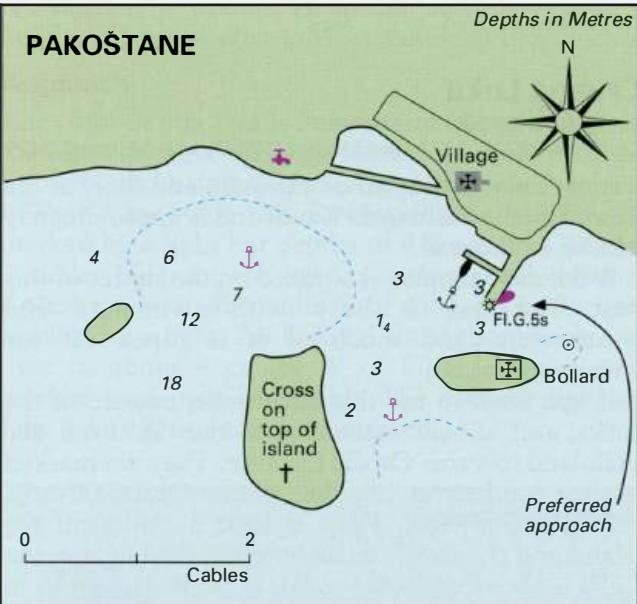
Three small islands lie in the approach to Pakostane. The small harbour is best approached by passing to the E of the most easterly island, on which there is a chapel. Take care to avoid the shoal to the NE of this island. Its presence is marked by a bollard. The area between the central island and the island to the E is shallow.
Lights
Pakostane pier head Fl.G.5s7m4M
Berth
A pier extends SW from the shore near the village. Tie up bow/stern-to this pier. Anchor Anchor NE of the westernmost island in 5 to Sm. The holding in sand is good.
Shelter
There is no shelter at Pakostane, either at the quay or at anchor, from W through S to SE. The anchorage is uncomfortable in even moderate SW winds, and is dangerous in strong SW winds.
Facilities
Water is available from a beach shower/tap W of the village. Fuel is some distance inland, on the Adriatic Highway. The village has a supermarket, fruit and vegetable market, bank, ATM, Post Office and telephones, medical centre, restaurants and cafe/bars.
History
The site was occupied before the Romans arrived. Pre-Roman burial sites, the foundations of a Roman villa, and parts of a Roman harbour wall have been found in and around the village. The small chapel on the easternmost island was built in 1670, as a memorial to the defeat of the Turks at the Battle of Lepanto in 1571. Crvena Luka