Region: South Adriatic
| Position: 43.125, 17.203333 | Adriatic Sea / Jadransko more
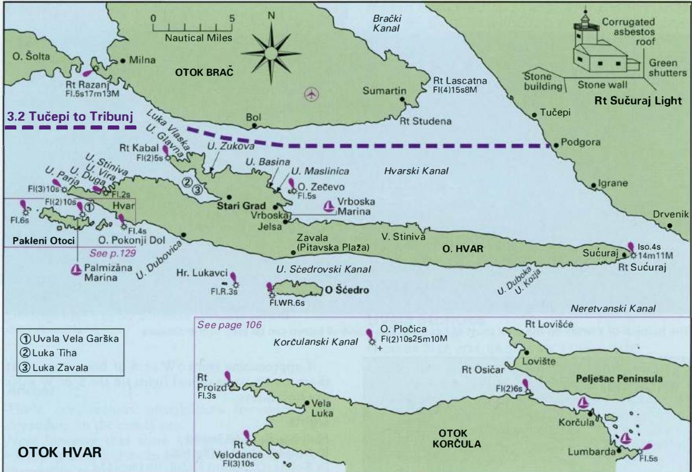
Rt Sueuraj 43°07"5N 17°12'.2E lso.4s14m11M Jelsa 43°1 O'N 16°42'-4E Fl.R.3s6m5M Rt Sv. Kriz (Vrboska) 43°10'.6N 16°41 'AE Fl.2s5m5M o. Zecevo 43°11 "5N 16°42"1 E Fl.5s11 m5M Rt Kabal 43°13'.5N 16°31'.5E Fl(2)5s16m7M 324°-vis-227° Rt Galijola (U. Vira) 43°1 1 "9N 16°25"8E Fl.2s8m6M Rt Fortin (Stari Grad) 43°11 'N 16°35'.5E Fl.G.2s9m4M Rt Pelegrin 43
General
Rt Sueuraj 43°07"5N 17°12'.2E lso.4s14m11M Jelsa 43°1 O'N 16°42'-4E Fl.R.3s6m5M Rt Sv. Kriz (Vrboska) 43°10'.6N 16°41 'AE Fl.2s5m5M o. Zecevo 43°11 "5N 16°42"1 E Fl.5s11 m5M Rt Kabal 43°13'.5N 16°31'.5E Fl(2)5s16m7M 324°-vis-227° Rt Galijola (U. Vira) 43°1 1 "9N 16°25"8E Fl.2s8m6M Rt Fortin (Stari Grad) 43°11 'N 16°35'.5E Fl.G.2s9m4M Rt Pelegrin 43°11'.7N 16°22'.3E Fl(3)10s21m8M 0. Vodnjak Veli 43°10'.1N 16°19'E Fl.6s31m9M 0. Galisnik 43°10'N 16°26"6E Fl.G.3s11 m5M 0. Pokonji Doi 43°09'-4N 16°27"4E Fl.4s20m10M
Coast Radio Stations
Rijeka VHF transmits and receives Kamenjak Ch 04; Savudrija Ch 81; Susak Ch 20; Vrh Ucka Ch 24 Traffic lists on VHF Ch 24 every odd H+35 Weather messages & Navigational warnings VHF Ch 04, 81, 20, 24 at 0535, 1435, 1935 Rijeka (MRCC) Note This station does not accept public correspondence, accepting Distress, Urgency and Safety traffic only VHF transmits and receives on Ch 16, 10 Split VHF transmits and receives on Brdo Hum Ch 81; Celavac Ch 28; Labistica Ch 21; Sveti Mihovil Ch 07; Vidova Gora Ch 23; Vrh Ucka Ch 21 Weather messages & Navigational warnings VHF Ch 81, 28, 21, 07, 23, 21 at 0545, 1245, 1945. Split (MRSC) Note This station does not accept public correspondence, accepting Distress, Urgency and Safety traffic only VHF Transmits and receives on Ch 16, 10 Split HM Office VHF Ch 67 Continuous Dubrovnik VHF transmits on Hum Ch 85; Srdj Ch 07; Uljenje Ch 04 Weather messages & Navigational warnings VHF Ch 85, 04, 07 at 0625, 1320, 2120 Dubrovnik (MRSC) Note This station does not accept public correspondence, accepting Distress, Urgency and Safety traffic onlyVHF Transmits and receives on Ch 16, 10 Dubrovnik HM Office VHF Ch 73 Continuous narrowing of the channel. In strong SE winds, which create a strong west-going current, there is usually a counter-current going E along the N side of 0. Hvar between Rt Pelegrin and Rt Kaba!. This countercurrent can reach 2 knots. In these conditions, the counter-current is weaker E of Rt Kabal, and often between Rt Kabal and Vrboska there will be no current close in. The Kanal Malog Stona is subject to seiches, which cause dramatic changes in water level and strong currents of variable direction. The harbour of Stari Grad on 0. Hvar has also experienced seiches in the past. The village of Vrboska on 0. Hvar can be flooded during a sirocco when the water level can rise by 2m. Such conditions can cause damage to vessels moored in the harbour.
Pilotage
MAINLAND COAST (CROATIA) Leaving the Boka Kotorska and proceeding north, all the harbours described in this and following chapters (with the exception of some anchorages in Zaljev Klek Neum, in Bosnia-Herzegovina) belong to Croatia, until the border with Slovenia is reached. Molunat