Otocic Badija
Region: South Adriatic
| Position: 42.951667, 17.166667 | Adriatic Sea / Jadransko more
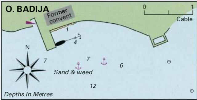
42°57'-1N 17°10'E Charts BA 7574, 683 (detailed), SC 5767, MK 22, lmray M26 The island of Badija off the E coast of Otok Koreula has a sheltered anchorage with clean water for swimming. The anchorage is S of the former convent or monastery, now used as a sports centre, and is set in attractive surroundings. The anchorage and quay lie on the S side
General
42°57'-1N 17°10'E Charts BA 7574, 683 (detailed), SC 5767, MK 22, lmray M26 The island of Badija off the E coast of Otok Koreula has a sheltered anchorage with clean water for swimming. The anchorage is S of the former convent or monastery, now used as a sports centre, and is set in attractive surroundings.
Approach
The anchorage and quay lie on the S side of Badija island and cannot be approached from E via the gap between the islands of Badija and Planjak, except by shallow draught craft. This shallow, rocky gap is marked by beacons. The safest and simplest approach is from N passing through the channel between Badija and Koreula. This channel, which is used by the car ferry, is lit at night. Note that in the approach to this channel there is a shallow patch, PliCina Kriz, which has less than 4m over it. Once through the narrow strait steer for the convent. Approaching from S there is a passage to the S and to the W of Otocic Vrnik, or to the S of OtoCic Planjak. Note however that there is an extensive area of shallows and rocks (Greben Krastovica) between Planjak and Vrnik. W of Planjak there are two islands, with rocks marked by an unlit beacon lying between them. Pass to the W of these islands. The quay at Otok Vrnik Approaching OtoCic' Vrnik from NW along Kanal Jezevica note that there is a shallow spit with depths of 2.5m over it extending 1 cable NE from Rt Soline on Otok Koreula, 51/2 cables SE of the Fl(2)R.5s light at the ferry berth. On the opposite side of the channel, W of OtoCic' Planjak, an unlit beacon marks some rocks, S and SW of it, which are awash. Approaching from NE beware of Greben Krastovica, a dangerous rock and shoal, lying NE of 0. Vrnik Approaching from SE, pass between Hrid Knezic', the small island NE of Uvala Tatinja, and OtoCic' Gubavac, the larger island lying N of it. Note that there is a shoal with just Sm over it 4 cables E of Hrid Knezic' (see plan). Uvala Racisce