Region: South Adriatic
| Position: 42.973333, 17.18 | Adriatic Sea / Jadransko more
42°58'-4N 17°10'.8E Charts BA 7574, 1580, 683 (detailed), SC 5767. MK 22. lmray M26 Orebic is the largest settlement on the southwestfacing coast of the Peljdac peninsula and is a popular holiday resort with several large hotels. It is also a car ferry port, with frequent crossings to Koreula, 2M away. A yacht basin has been built in recent years i
General
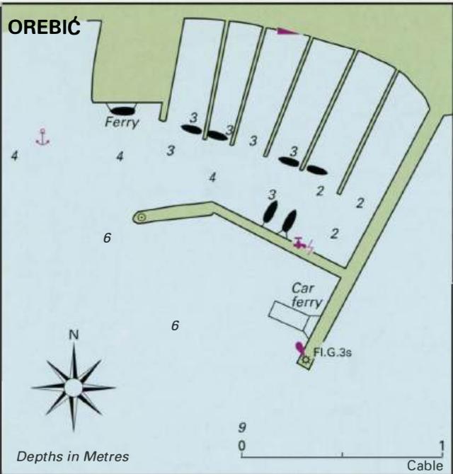
42°58'-4N 17°10'.8E Charts BA 7574, 1580, 683 (detailed), SC 5767. MK 22. lmray M26 Orebic is the largest settlement on the southwestfacing coast of the Peljdac peninsula and is a popular holiday resort with several large hotels. It is also a car ferry port, with frequent crossings to Koreula, 2M away. A yacht basin has been built in recent years improving the shelter and facilities for yachts.
Approach
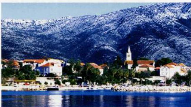
The houses and hotels of Orebic are conspicuous. The harbour lies towards the W end of the town. If approaching from W the passage through the Peljdki Kanai is straightforward. Follow the mainland shore keeping at least 2 cables offshore. The coast in the region of Orebic is shallow close inshore, especially in Zaljev Trstenica, the bay to the NE. Approaching from S there are a number of islands and rocks off the NE part of Otok Koreula, but as long as the chart is consulted, approach is not difficult. Coming from SE pass to the N of the islands of Sestrica Vela and Sestrica Mala, particularly at night, and then steer for Orebic. In the nearer approach, beware of the ferries, which berth at the end of the main breakwater. The harbour should not be approached in strong S or W winds. The entrance to the yacht basin at Orebic
Lights
0. Sestrica Vela Fl(4)15s18ml1M 0. Stupe Vele Fl.R.3s9m3M 085°,-vis-261° Korcula town Fl.G.5s7m4M Orebic breakwater head Fl.G.3s8m3M The entrance to the yacht basin was not lit in 2007, although there was a light structure in position.
Berth
Enter the yacht basin and go bow/stern-to the S mole, picking up one of the pick-ups provided. Alternatively, moor bow/stern-to one of the pontoons. Anchor Anchor to the W of the harbour in 4m, keeping clear of the passenger ferry. Anchoring here at night is not recommended, since an anchor light would not be Good all-round shelter can be found inside the yacht basin, although some swell from W will make the harbour uncomfortable.
Officials
Harbourmaster. Police.
Facilities
Water and electricity are laid onto the S mole in the yacht basin. o fuel in the town {the nearest source of fuel is close to the ferry berth on Otok Korcula, W of 0. Badija). Several supermarkets, butchers, daily fruit and vegetable market. Banks. ATM. Post Office. Telephones. Medical centre and first-aid post. Tourist information. Hotels, restaurants, cafe/bars. Mechanical repairs are possible. Bus and ferry service. Taxis.
History
Orebic used to be known as Trstenica, but it gained its present name in the 16th century from the Orebic family who built themselves a castle at nearby Karmena in 1568. In the past, many of the Orebic menfolk were seamen, and this seafaring tradition is reflected in the small maritime museum. There are also two private collections of nautical paraphernalia and souvenirs brought back from foreign lands by the sea captains in the families. To see these private collections ask at the tourist information office. Uvala Luka and Loviste
Adriatic Navigation Guide Images for Orebic
Adriatic Navigation Guide images and captions provide additional visual reference for this navigation location.