Muline
Region: Central Adriatic
| Position: 44.14, 15.073333 | Adriatic Sea / Jadransko more
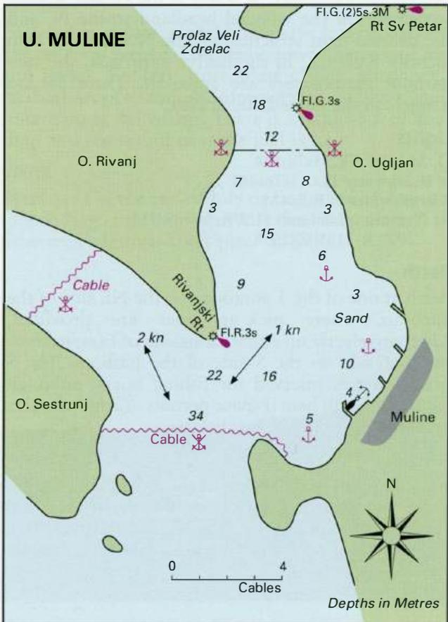
44°08'-4N 15°04'-4E Charts BA 515, SC 5767, MK 13, lmray M25 There is a sheltered anchorage with a pier, in the bay near Muline on the NE end of Otok Ugljan. The Alternatively, anchor in a suitable depth, away from the centre of the channel, in a position giving the best shelter in the prevailing conditions. In a bora take lines ashore. The bottom
General
44°08'-4N 15°04'-4E Charts BA 515, SC 5767, MK 13, lmray M25 There is a sheltered anchorage with a pier, in the bay near Muline on the NE end of Otok Ugljan. The Alternatively, anchor in a suitable depth, away from the centre of the channel, in a position giving the best shelter in the prevailing conditions. In a bora take lines ashore. The bottom consists mostly of sand, although there are patches of rock towards the centre of the channel. A number of interesting ruins are to be seen at Muline, including the remains of a Roman villa, a Roman pier, a mill (which explains the origins of the village's name), a mausoleum, etc. Ugljan