Maslinica
Region: Central Adriatic
| Position: 43.396667, 16.21 | Adriatic Sea / Jadransko more
43°23'.8N 16°12'.6E Charts BA 2712, 2774, SC 5767, MK 76, lmray M26 Maslinica is a small village on the west side of Otok Solta, YfM north of Uvala Sefola. A number of islands and shoals lie off this coast. Hrid KamiCic, a rock surrounded by a shoal, lies S of the islands 6 cables SW of the entrance to Uvala Sefola. Hrid Kamicic is in the red secto
General
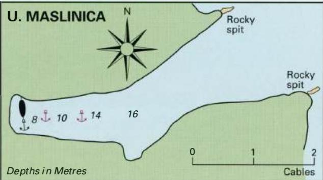
43°23'.8N 16°12'.6E Charts BA 2712, 2774, SC 5767, MK 76, lmray M26 Maslinica is a small village on the west side of Otok Solta, YfM north of Uvala Sefola. A number of islands and shoals lie off this coast. Hrid KamiCic, a rock surrounded by a shoal, lies S of the islands 6 cables SW of the entrance to Uvala Sefola. Hrid Kamicic is in the red sector of the light on Rt Sveti Nikola Fl.WR.3s10m7/4M, 011°-R-056°-W-Oll 0, the headland between Uvala Sefola and Maslinica. Approaching from the N beware of the shoals between the islands of Polebrnjak and Saskinja (5m and less), and between Saskinja and Solta (3m). There is deep water outside of 0. Polebrnjak. Visitors' berths are bow/stern to the S quay, where lines have been laid, and water and electricity connections installed. The 'ferry' berth is used by tripping boats throughout the day. Good all-round shelter is available at Maslinica, although in strong W winds some swell finds its way into the harbour. The village has a supermarket, Post Office, telephone, tourist information, hotel, and some restaurants and cafe/bars. Uvala Donja Krusica
Adriatic Navigation Guide Images for Maslinica
Adriatic Navigation Guide images and captions provide additional visual reference for this navigation location.