Luka Vlaska
Region: Central Adriatic
| Position: 43.21, 16.588333 | Adriatic Sea / Jadransko more
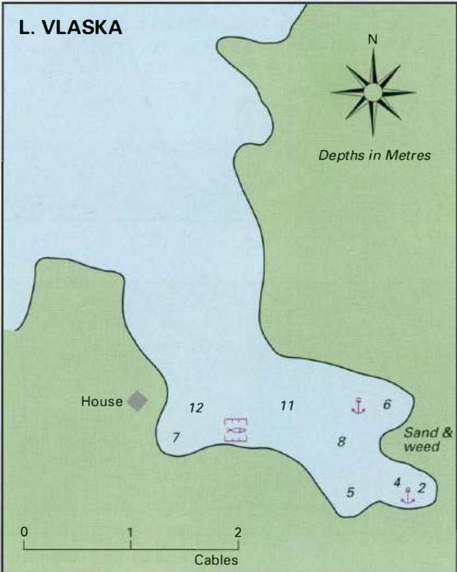
43°13"SN 16°33"2E Charts BA 2712, SC 5767, MK 19, lmray M26 Luka Vlaska is an unspoilt bay, which offers good shelter from all directions except NW. The bay is just over lM east of Rt Kabal. There are no dangers in the approach. Anchor in an appropriate depth, avoiding the fish farm, taking lines ashore if necessary. The bottom is sand and weed. Th
General
43°13"SN 16°33"2E Charts BA 2712, SC 5767, MK 19, lmray M26 Luka Vlaska is an unspoilt bay, which offers good shelter from all directions except NW. The bay is just over lM east of Rt Kabal. There are no dangers in the approach. Anchor in an appropriate depth, avoiding the fish farm, taking lines ashore if necessary. The bottom is sand and weed. There are no facilities ashore. 43°12'-6N 16°35'.3E Charts BA 2712, SC 5767, MK 19, lmray M26 Uvala Zukova is located on the N coast of Hvar, at the root of the peninsula, which protects Starogradski Zaljev from the N. The cove is popular with holidaymakers from Stari Grad. There are however no facilities ashore. There are no dangers in the approach. Anchor in an appropriate depth (see plan), taking a line ashore if necessary. The bottom is sand and weed. The bay is open to the N and NE but it is possible to obtain some shelter from these directions tucked behind the small headland, which projects W into the cove. Shelter is good from all other directions. Uvala Basina
Adriatic Navigation Guide Images for Luka Vlaska
Adriatic Navigation Guide images and captions provide additional visual reference for this navigation location.