Professional navigation chart centered on Luka Velji Lago
Luka Velji Lago
Region: South Adriatic
| Position: 42.75, 16.825 | Adriatic Sea / Jadransko more
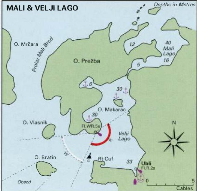
42°45'N 16°49'.5E Charts BA 1574, 2712, SC 5767, MK 27, 23, lmray M26 Luka Velji Lago is a generally deep inlet formed by Otok Lastovo to the E and Otok Prezba to the N and W. The entrance lies on the W side of Lastovo. Good all-round shelter can be found in various parts of the bay. Note, however, that here the bora blows from the N, that in stron
General
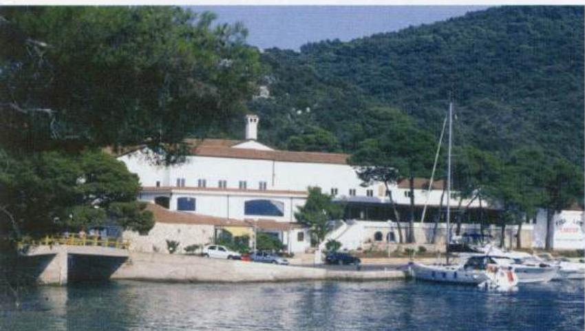
42°45'N 16°49'.5E Charts BA 1574, 2712, SC 5767, MK 27, 23, lmray M26 Luka Velji Lago is a generally deep inlet formed by Otok Lastovo to the E and Otok Prezba to the N and W. The entrance lies on the W side of Lastovo. Good all-round shelter can be found in various parts of the bay. Note, however, that here the bora blows from the N, that in strong SE winds strong squalls occur, and that strong SW winds can create an uncomfortable swell. Medical assistance, provisions, fuel and water are available at the village of Ubli, which is on Lastovo just inside the entrance to the anchorage. Ubli is also a port of entry. At the far NE end of Luka Velji Lago, close to the small boat channel leading to Luka Mali Lago, there is a small marina attached to a diving centre and hotel A small new marina has been established in the N part of Luka Velji Lago, next to the bridge connecting Otok Lastovo to Otok Prezba.
Approach
The approach to Luka Velji Lago requires care because of the off-lying islands and the shoal lying off Rt Cuf, the W headland of Lastovo. Entering from S pass midway between Otok Bratin and Lastovo and continue on a N course until the unlit buoy marking the shoal off Rt Cuf (reported missing in September 2006) is abeam. Then turn into the anchorage passing to the N of the buoy. Approaching from N note that there is a shoal patch with Sm over it up to 3 cables W of OtoCic Pod Mrearu on which there is a light (Fl(2)6s23m9M). To the SW and S there are two more shoals with 15m and 10.5m over them lying in deep water. In bad weather, you may encounter rough seas in the vicinity of these shallower areas. Approximately 1 .6M west-southwest of OtoCic Mrcara there is an unlit islet with shoals around it. Once you have passed OtoCic Mreara you can pass to the N or S of Otok Bratin. Enter the harbour passing to the N of the unlit buoy on the S side of the entrance off Rt Cuf. At night, the safe approach is indicated by the white sectors of the light on Rt Kremene.
Lights
Otocic Pod Mrearu Fl(2)6s23m9M Rt Struga Fl.10sl04m27M 259°-vis-095° Rt Kremene (SE headland of Otok Prezba) FLWR.5s1 8m8/5M 067°-W-084° and 235°-R-023°-W 0450 Ubli quay Fl.R.2s8m2M
Berth
A ferry berth and quay are located in the SE corner of Luka Velji Lago at Ubli. It is possible to tie up alongside the quay NE of the fuel berth. This is a temporary berth whilst clearing customs as this quay is used by a catamaran and the ferry. Do not leave the boat unattended. It is also possible to berth at the marina in the N part of Luka Velji Lago, where pickup lines are provided. The marina address is: Marina & Loding Solitude -Ladesta, Pasadur bb, 2029 Ubli-Lastovo, Croatia 'fi' (020) 805 002 Fax (020) 805 014 Email [email protected] Anchor Anchor in Uvala Kremene, the inlet N of Rt Kremene, in depths of 15m, or N of the island of Makarac. Depths midway between Makarac and Prezba are 30m, so anchor closer in and take lines ashore if necessary to prevent the anchor dragging into deeper water. It is also possible to anchor in the shallower bay, in the NW part of Luka Velji Lago where there are former military quays.
Shelter
All round shelter is available.
Officials
Harbourmaster near the ferry berth. Police. Permanent port of entry.
Facilities
Marina Water and electricity laid onto the marina berths. Toilets in hotel. Mini-market with basic essentials. Exchange facilities. Hotel, restaurant, bar. Diving centre. Ubli Water from the fuel berth (not always available). Fuel berth with 2.5 -4.5m alongside. It is open between 0600 and 2200. Small supermarket, Post Office and telephone in the village on the road to Lastovo. Cafe. Bus service to Lastovo village. Ferry to Split and to Vela Luka on Otok Koreula.
History
Archaeological evidence indicates that Otok Lastovo was inhabited during the Bronze Age. The island was colonised by the Romans, who built a number of villas here, and had their main settlement at Ubli. The importance of Otok Lastovo to the Romans is indicated by its title, Augusta Insula. The foundations of an early Christian basilica can still be seen at Ubli. Luka Mali Lago
Adriatic Navigation Guide Images for Luka Velji Lago
Adriatic Navigation Guide images and captions provide additional visual reference for this navigation location.
At the far NE end of Luka Velji Lago, close to the small boat channel leading to Luka Mali Lago, there is a small marina attached to a diving centre and hotel