Luka Soline
Region: South Adriatic
| Position: 43.155, 16.371667 | Adriatic Sea / Jadransko more
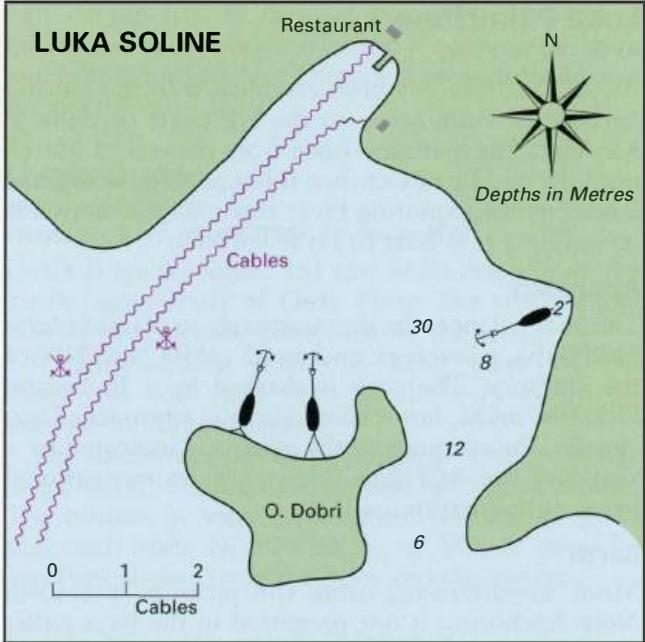
43°09'-3N 16°22'-3E This large bay on the S coast of Otok Sveti Klement, almost at the centre point of the island, is very deep in the centre. It is sheltered from S by OtoCic Dobri. Cables come ashore on the NW shore of Luka Soline. The best anchorage for a yacht is on the E Uvala Vlaka is located on the N shore of Otok Sveti Klement. There is a p
General
43°09'-3N 16°22'-3E This large bay on the S coast of Otok Sveti Klement, almost at the centre point of the island, is very deep in the centre. It is sheltered from S by OtoCic Dobri. Cables come ashore on the NW shore of Luka Soline. The best anchorage for a yacht is on the E Uvala Vlaka is located on the N shore of Otok Sveti Klement. There is a pier in this inlet for the village. It is not possible to anchor on the E side of the bay because of a cable which comes ashore here. The best anchorage is to the S of the off-lying island of Otocic Vlaka. Anchor in 8m, sand. Uvala Duboka Vela
Adriatic Navigation Guide Images for Luka Soline
Adriatic Navigation Guide images and captions provide additional visual reference for this navigation location.