Luka (Sipanska Luka)
Region: South Adriatic
| Position: 42.755, 17.836667 | Adriatic Sea / Jadransko more
42°43"8N 17°51 "9E Charts BA 1580, SC 5767. MK 25, 26. lmray M26 Luka is the main settlement on Sipan. It lies at the head of a long narrow inlet, which is fringed by wooded slopes. Approaching Luka from the mainland side of 0. Sipan and 0. Jakljan (via the Kolocepski Kanal) there are no off-lying dangers, other than a chain of islands extending SE
General
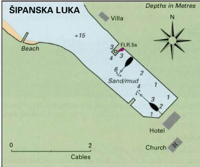
42°43"8N 17°51 "9E Charts BA 1580, SC 5767. MK 25, 26. lmray M26 Luka is the main settlement on Sipan. It lies at the head of a long narrow inlet, which is fringed by wooded slopes.
Approach
Approaching Luka from the mainland side of 0. Sipan and 0. Jakljan (via the Kolocepski Kanal) there are no off-lying dangers, other than a chain of islands extending SE from 0. Tajan and parallel to Otok Jakljan. If approaching from the SW side of Sipan or Jakljan it is possible to pass through the Prolaz Harpoti, the narrow strait separating Jakljan from Sipan. The strait is not lit and approach should not be attempted after dark, nor should it be approached in strong onshore seas. The passage through the Prolaz Harpoti is straightforward. On the NW side of the strait are two small inlets which have rocks near their entrances (see plan of Prolaz Harpoti). A highvoltage electricity cable, with an air clearance of 46m, crosses the strait at its narrowest point. Rounding the W peninsula of Sipan, there is a shallower patch with 4. 7m over it extending N and NE. The village of Luka is visible at the end of Sipanska Luka.
Lights
Otok Tajan Fl.R.3s9m4M 061°-vis-268° Rt Tiha Fl(2)8s14m9M 117°-vis-305° Luka pier Fl.R.5s7m3M Anchor S of the light on the quay in 6m. The bottom is mud and sand. Ensure that you have anchored well clear of the ferry berth, since the ferry needs of room in which to reverse and turn. It leaves Luka in the early hours!
Shelter
The harbour offers excellent shelter from all directions with the exception of NW and SW winds.
Facilities
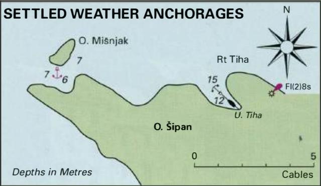
There is one general store selling bread and groceries, and a Post Office. Telephones. Hotel, restaurants, cafe/bars. Medical centre. Ferry to the mainland and to the other islands. No public water tap here and no fuel. o. Misnjak 42°45"3N 17°50'.2E Charts BA 1580, SC 5767. MK 25. lmray M26 There is an anchorage between 0. Sipan and 0. Mifojak, which is suitable in settled weather. Anchor in 6m. The bottom is sand and weed. The anchorage is sheltered from the S and SE. Uvala Tiha
Adriatic Navigation Guide Images for Luka (Sipanska Luka)
Adriatic Navigation Guide images and captions provide additional visual reference for this navigation location.