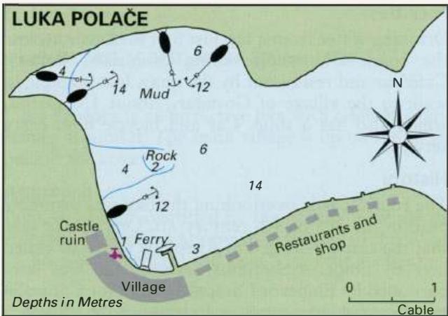
Professional navigation chart centered on Luka Polace
Luka Polace
Region: South Adriatic
| Position: 42.79, 17.38 | Adriatic Sea / Jadransko more
42°47'-4N 17°22'.8E Charts BA 1580, SC 5767, MK 24, lmray M26 Luka Palace is a spacious anchorage towards the west of the island, on the north-facing coast of Mljet. It is located at the far end of a long inlet, which is protected by four wooded islands lying in its approach. Being landlocked Luka Palace is one of the most sheltered anchorages in t
General
42°47'-4N 17°22'.8E Charts BA 1580, SC 5767, MK 24, lmray M26 Luka Palace is a spacious anchorage towards the west of the island, on the north-facing coast of Mljet. It is located at the far end of a long inlet, which is protected by four wooded islands lying in its approach. Being landlocked Luka Palace is one of the most sheltered anchorages in this area. If you wish to explore Mljet overland and go to see the lakes, Luka Palace is the safest place to leave the boat. There are footpaths leading to and around the lakes. The walk is highly recommended because of the beautiful scenery. It is also possible to go on a tour from Luka Palace to the lakes. Tickets can be bought from the kiosk near the castle. The tour includes a bus to the lakes and a boat trip out to the island of Sv. Marija, to visit the former monastery.
Approach
Approaching from E or SE the main entrance to Luka Palace lies between the main island of Otok Mljet and the island of 0. Kobrava. The light structure on Hrid Kula, a rocky islet lying nearly midway between Mljet and 0. Kobrava, helps identify the entrance. Pass to the N of Hrid Kula. From here, there are no dangers and the channel leading to Luka Palace is straightforward, although it is not lit. Approaching from N or W beware of the rock, only just below the surface, 1 Y2 cables E of the island at the entrance to Uvala Stupa. From this direction, the channel into Luka Polace lies between the main island of Mljet and the island of Moraenik. Note that the islet just inside the entrance, 0. Skoljic, has a rocky spit extending W underwater. Pass to the W of 0. Skoljic and then keep to the middle of the channel. Note that there is a low promontory ahead extending E into the channel. This promontory consists of a rocky ridge, only inches above sea level. This can be difficult to see, even in daylight. Just SE of this promontory there is a rock off 0. Moraenik, but this has 5.5m over it. It is possible to enter Luka Palace between the islands of Ovrata and Kobrava. There are no hazards in this approach.
Lights
Hrid Kula Fl.2sllm6M
Berth
Staying clear of the ferry berth, moor bow to the quay near the castle, although beware that depths are less than lm in parts. The quayside E of the ferry berth is claimed by the various restaurants here. Restaurant patrons can berth at their quays free of charge. Some of the quays have laid lines. Anchor Anchor in the N part of the bay where the best shelter is to be found. The bottom is mud, excellent holding. Note that there is a rocky patch NE of the ruined castle. Holding to the W of this rocky patch is unreliable, and there are rocks, which can trap anchors and chain. During the season a charge is levied for anchoring. 0. V. It is possible to find a quiet and sheltered anchorage near the islands, e.g. on the S side of 0. Kobrava or 0. Moraenik, dropping an anchor and taking a line ashore.
Shelter
Excellent all-round shelter from winds and seas.
Facilities
Drinking water from a tap just S of the castle, across the road. One shop selling essentials. Bakery. Cafe/bar and restaurant by the quay. It is possible to walk to the village of Govedari, about lM inland, which also has a shop. Car and bicycle hire. Ferry service.
History
The ruined castle overlooking the bay was probably built in the 3rd or 4th century AD. One source says that the castle belonged to Agesilaus who was exiled here by Emperor Septimus Severus, and was later pardoned by Emperor Caracalla. Emperor Caracalla was persuaded to the act of clemency by reading a poem written by Agesilaus' son, Oppianus. Next to the castle are the ruins of an early 5th-century Christian basilica. The present village, which grew up in and around the ruins of the castle, was established in the 18th century. Kozarica
Adriatic Navigation Guide Images for Luka Polace
Adriatic Navigation Guide images and captions provide additional visual reference for this navigation location.