Luka Muna
General
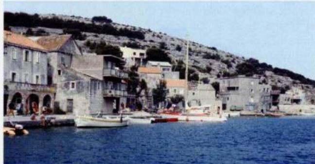
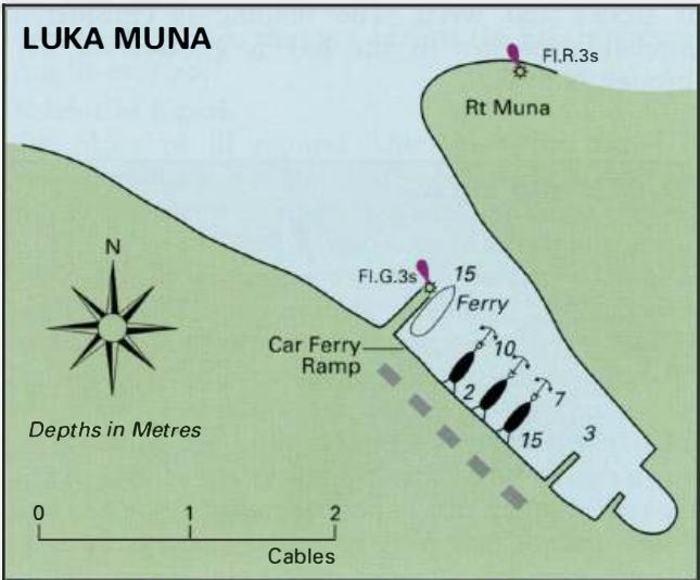
43°39'.6N 15°39'.6E Charts BA 2711, 2774, MK 15 Luka Muna can be identified by the light structure on Rt Muna Fl.R.3s9m2M, the headland at the entrance to the bay, and by the light beacon marking PliCina Brak PrasCica Fl(2)10s6m7M. Pl. Brak PrasCica lies approximately lM northwest of the harbour. There is a light exhibited from the end of the pier Fl.G.3s6m2M within the harbour. Luka Muna on Otok Zirje is a quiet harbour U. TRATINSKA Luka Muna on Otok Zirje: Visitors can moor at the root of the main pier, but should be prepared to move for the ferry The outer pier is used by the ferry. Yachts tie up bow/stern-to the SW quayside, beyond the pier and car ferry ramp. The bottom is sand. Shelter in the harbour is good from NE through S to W. Facilities in Muna itself are limited to a restaurant, bar, and a map of the island's facilities. Uvala Stupica Vela 43"38'N 15"41 '.8E Charts BA 2774, 2711, SC 5767, MK 15, lmray M25 Uvala Stupica Vela lies on the S coast of Otok Zirje. It is the most W of three bays and the anchorage here offers the best shelter. Not surprisingly, it is a popular anchorage. The other two bays E, Uvala Stupica Mala and Uvala Kabal, are either too deep or are rocky, and are usually deserted. Approaching Uvala Stupica Vela pass well S of the red light structure (Fl(2)R.5s5M) approximately 2 cables S of Rt Rasohe, the southernmost extremity of Otok Zirje. On entering Uvala Stupica Vela, note that a shallow area with less than 3m over it extends from the E headland. Anchor in an appropriate depth, or anchor and take a line ashore. The bottom is sand with patches of stones and weed. The holding is considered unreliable. Shelter in the bay is good from SW through N to E. Cables Depths in Metres Uvala Tratinska 43"39'.8N 15"37'-SE Charts BA 2711, 2774, SC 5767, MK 15, lmray M25 Uvala Tratinska lies on the south-facing coast of Otok Zirje, towards the north part of the island. The anchorage has a few holiday houses nearby. Approaching the bay from N do not pass too closely to Rt Ljuta because of a shallow area extending nearly 2 cables offshore. There are otherwise no dangers in the immediate approach to Uvala Tratinska. Anchor in an appropriate depth, and take lines ashore in a bora. The bay is sheltered from SW through N to E, although in strong SW winds some swell enters the bay. Uvala Mikavica 43"40'.2N 15"37'-6E Charts BA 271 1, 2774, SC 5767, MK 15, lmray M25 Uvala Mikavica lies on the N coast of Otok Zirje, approximately lM to the W of the beacon marking PliCina Brak Prascica Fl(2)10s6m7M. It is a deserted inlet with a quay used by the occasional tripping boat in the summer. Approaching the bay, beware of the small islet and shoal to the NW. Depths of less than 3m extend up to 2 cables S and SE of the island Anchor in Uvala Mikavica in 5m, or go bow/sternto the pier. The bora blows strongly here. Shelter is good from E through S to W. 3.3 Croatia Murter to Rab The area covered by this chapter covers the mainland coast from N of Tribunj (described in the previous chapter) to Luka Sv. Juraj (also called Jurjevo), which is approximately 4M south of Senj. The off-lying islands described include Murter, the Kornati Islands, Pasman, Ugljan, Dugi Otok, Molar, Pag, Olib, Silba, Premuda and Rab. National parks Kornati Islands The Kornati Islands have been designated a national park and are being developed as a tourist attraction. Special regulations are in force to protect the islands. Most of the regulations are a matter of common sense, and prohibit damaging the environment or harming the flora and fauna. Visitors have to pay an entrance fee, which can be paid at one of the reception areas or to one of the park patrol boats. Anchoring during the day or for the night is allowed in the majority of anchorages. There are just a few areas where stopping is prohibited. These are the islands of Klobucar, Mrtvac, and Veli and Mali Obruean. At the far S end of the islands yachts are not allowed within 500m of the island of Velika Purara or the off-lying reefs of Klint and Volic. The old church of Our Lady of Tarac on Otok Kornat is still in use. There is evidence that in the past there was a bigger church on this site The view looking SE along the Kornatski Kanai from the ruined castle of Tureta on Otok Kornat. Luka TelasCica Luka TelasCica, at the S end of Dugi Otok, used to be part of the Kornati National Park, but it is now a nature park in its own right, with a separate administration. Again, regulations are a matter of common sense. Yachts anchoring within the boundaries of the park are visited by wardens, who collect an entrance fee and take away rubbish.
Local Weather Effects
The afternoon sea breeze in this area tends to blow from the NW. On occasion, it can reach up to Force 5 or 6, particularly in August. If the sea breeze is blowing against the tide or current, it will create short steep seas. Pasmanski Kanai and Zadarski Kanal In the channels between the mainland and Pasman {the Pasmanski Kanai) and the mainland and Ugljan (Zadarski Kanal) the bora can raise a short steep sea. The sirocco can create breaking waves, when the wind is against the tide. Winds from SW are deflected by the off-lying islands of Pasman and Ugljan and tend to blow from the S. The off-lying islands Both the bora and the sirocco can blow strongly among the islands of Kornati, Dugi Otok, Zut, and their surrounding waters. The effect that the wind has depends on the exact location. ear Otok Zut the bora blows from the E, and does not create large seas. Farther N, in the vicinity of Otok IZ, any strong N wind creates big seas. In strong winds that are against the tide large seas can be created. Velebitski Kanal Oh place of ill repute! The Velebitski Kanal is perhaps the most feared part of the whole Adriatic coast. The steep mountains come right down to the sea all along the mainland coast. The bora which can fall from the mountain tops without any warning is particularly dangerous here. The danger lies not only in the strength of the wind, but also in the lack of havens in which to shelter. The reputation of the Velebitski Kanal springs largely from the winter gales, when the bora can regularly reach Force 12. There are stories of lamp posts being blown down and of people being trapped in cars because they are unable to open the doors. In the summer these conditions do not occur, although the bora can still s. Blaz Fl.5s10M )> 0 ;;o -I 0 o. Visoki o. cZc;je. , L<? Fl.3s6M F1121WA.10s 13m8/6M \ 48 Hr Galijola Fl.5s21m12M Zaljev 48 3.4 Senj to Slovenia , ____ ,. : 3.3 Murter to Rab See p.287 CROATIA Marina Simuni _ . Lukovo Sugaqe Otok Olib L. Olib L. Sv. Nikola Otok Pag Pag Zubovici Caska Povljana Kosljun Simuni U. Mandre Novalja 0 0 '1l c *AH *AH c Ol B A c 285 B 286 B c B 287 c c -288 B B -288 B -232 B -232 B -288 B -289 A A c 289 B -290 B B Murter to Rab -Major Lights VELESITSKI KANAL (S)
Adriatic Navigation Guide Images for Luka Muna
Adriatic Navigation Guide images and captions provide additional visual reference for this navigation location.