Luka Milna
Region: Central Adriatic
| Position: 43.326667, 16.45 | Adriatic Sea / Jadransko more
43°19"6N 16°27'E Charts BA 2772, SC 5767, MK 18, lmray M26 The harbour at Milna is the most sheltered on Brae, a fact which has been recognised by previous generations of seafarers. The harbour was the base of the Russian Adriatic fleet in 1807, and before that had been an important harbour for the Venetian fleet. Today there is an ACI marina in th
General
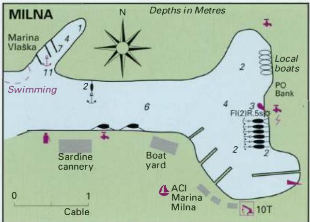
43°19"6N 16°27'E Charts BA 2772, SC 5767, MK 18, lmray M26 The harbour at Milna is the most sheltered on Brae, a fact which has been recognised by previous generations of seafarers. The harbour was the base of the Russian Adriatic fleet in 1807, and before that had been an important harbour for the Venetian fleet. Today there is an ACI marina in the SE part of the harbour and Marina Vlaska near the entrance. Milna: the town quay is in the background on the left, and the ACI marina is on the right-hand side of the photograph Milna lies on the W side of Brae in particularly pleasant surroundings. The town has some attractive buildings and is popular with visitors, including flotilla yachts. On one of our visits we counted 18 flotilla yachts stern-to the quay.
Approach
The inlet leading to Milna can be identified by the off-lying island of Mrduja on which there is a light, and the light structure on the headland (Rt Bijaka) to the of the entrance. There are no dangers in the approach.
Lights
0. Mrduja Fl.G.3s14m4M Rt Bijaka Fl.R.3s8m3M Milna quay Fl(2)R.5s7m4M (this can be difficult to see against the background of street lights)
Berth
The ACI marina has a reception berth immediately to the E of the shipyard. Tie up here to obtain directions from marina staff. If directed to the quay opposite the fish cannery, beware. This is particularly uncomfortable when the ferry arrives and departs, because it goes past this stretch at speed. If tied up here make sure you are not too close to the quay, otherwise you might sustain some damage. It is also possible to moor bow/stern to the main quay, providing you arrive before the flotilla fleets! The quay S of the light is administered by the ACI marina and has laid lines. A marina, separate from the ACI group, operates in the inlet on the NW side of the harbour. It is called Marina Vlaska.
Shelter
Shelter from all wind directions is available in various parts of the harbour, although the bora (which here blows from the E) is very strong. Good all-round shelter is available, although in strong SW winds some swell penetrates the harbour.
Officials
Harbourmaster. The town quay at Mi Ina Marina Vlaska is one of two marinas in Milna
Facilities
The berths at both marinas have water and electricity. Water is available from a standpipe on the quay, mornings and evenings, and from the fish cannery. Fuel is available from the fuel berth W of the sardine cannery. The fuel berth has depths of 3m, and is open between 0600 and 2200. Supermarkets, grocer, greengrocer, butcher, baker. Fruit and vegetable market. Hardware shop. Bank and ATM. The fuel berth at Mi Ina Anchor The best anchorage is in the N arm of the inlet. Anchor here in a suitable depth, taking lines to the shore. The bottom is mud and good holding. Water and electricity are available on the N quay. There is only the one grocery shop. Fresh fish is sometimes sold directly from the fishing boats. A small cafe/bar/restaurant. Bus service connecting with the ferry to Split from Supetar. Uvala Stipanska
Adriatic Navigation Guide Images for Luka Milna
Adriatic Navigation Guide images and captions provide additional visual reference for this navigation location.