KrusCica and Uvala KrusCica Duboka
Region: Central Adriatic
| Position: 44.348333, 15.321667 | Adriatic Sea / Jadransko more
Krusdca 44°20'.9N 15°19'.3E Uvala Krusdca Duboka 44°21'.1N 15°19'E Charts BA 575, MK 72, MK 70, lmray M25 KrusCica is a small village on the northeast coast of the Velebitski Kanal approximately 2YiM northeast of the Ljubacka Vrata. It has a pier and two bollards used . by local fishing crafr The busy Adriatic Highway runs around the cove. Ashore a
General
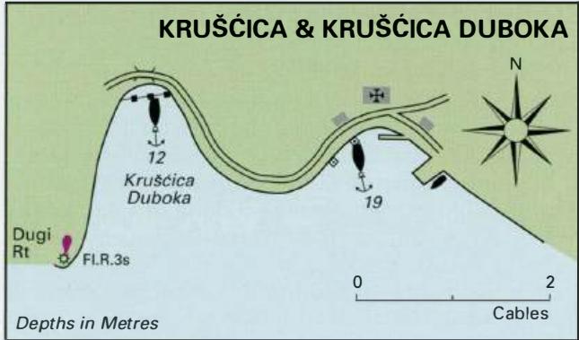
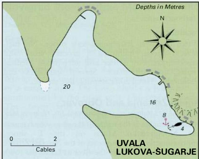
Krusdca 44°20'.9N 15°19'.3E Uvala Krusdca Duboka 44°21'.1N 15°19'E Charts BA 575, MK 72, MK 70, lmray M25 KrusCica is a small village on the northeast coast of the Velebitski Kanal approximately 2YiM northeast of the Ljubacka Vrata. It has a pier and two bollards used . by local fishing crafr The busy Adriatic Highway runs around the cove. Ashore are some restaurants and a shop. The next bay to the NW, Uvala KrusCica Duboka, is a hara haven. It has three bollards at the head of the bay for taking shore lines in a hara. Anchor in lOm (mud) and take lines ashore, which are essential in a hara. Uvala KrusCica Duboka is easily located because of the light structure on Dugi Rt to the W (Fl.R.3s6m5M). The light structure is surrounded by cypress and pine trees. Approaching from S beware of an isolated rocky shoal, Pl. Grabovaca, with 4.6m over it, which lies 2 cables offshore approximately lM southeast of Dugi Rt. Uvala Lukovo-Sugarje
Adriatic Navigation Guide Images for KrusCica and Uvala KrusCica Duboka
Adriatic Navigation Guide images and captions provide additional visual reference for this navigation location.