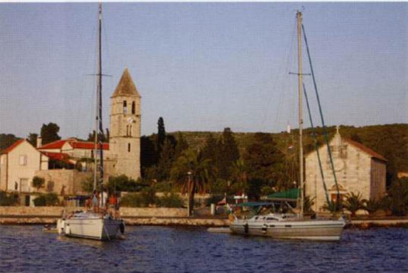
Komiža
General
43°02'.7N 16°05'.5E Charts BA 2772, 2774, SC 5767, MK 7 7, lmray M26 The picturesque town and sheltered harbour of Komifa lie in the NE corner of the wide bay of Zaljev Komifa on the W coast of Otok Vis. The harbour is home to Comeza-Lisboa, a reproduction gajeta falkufa, which was built for Expo '98 in Lisbon. The gajeta falkusa is a lateen-rigged traditional fishing boat, the history of which is believed to go back to the time of the Greeks. It is a fishing boat, which, uniquely for this area, was intended for deep-sea fishing. In the past a regatta used to take place on the feast of St Anthony, when a fleet of falkufa would set sail from Komifa bound for Otok Palagrufa. The last regatta was held in 1936, but on 18 September 1998 Comeza-Lisboa set off to repeat this journey. It is hoped that in future other lateen-rigged vessels will participate and so resurrect the regatta.
Approach
Komifa lies in the far NE corner of Zaljev Komifa and is easy to identify. The harbour breakwater has a light on the end and shows up well. There are no dangers in the immediate approach to the harbour, although rocks fringe the shore of Zaljev Komifa close in. Approaching from N pass to the W of the island of Mali Barjak on which there is a white stone light structure. Rocks surround the island, which lies The harbour of Komifa on the west coast of Otok Vis. The island of Bisevo can be seen in the distance If approaching from SW or S of Bisevo note that there are no navigational lights on the S or W sides of Otok Bisevo. The town of Hvar lies on the W end of Otok Hvar. Approaching from seaward the radio mast NW of the town (with a red light at night) is conspicuous. The fort above the town and the town walls are also easily distinguishable. Approaching from S or E, pass either side of Otocic Pokonji Dol with its distinctive lighthouse. If passing to the S note that a shallow spit with Sm over it extends 1 cable S from 0. Pokonji Doi. From 0. Pokonji Dol pass to the E of 0. Jerolim. A number of isolated shoals lie in the vicinity of 0. Jerolim. One, with Sm over it, lies to the E of it 0. Jerolim, and two with 6m and Sm lie to the S of the island. In bad weather seas may break in the areas of these shoals. Hvar harbour seen from the citadel at the height of the season with the Pakleni Islands in the background. The main quay on the left, where large yachts berth, soon fills up. Other yachts then either anchor, or anchor and take lines ashore like the raft of yachts in the top right of the photograph Between Otok Jerolim and the town of Hvar there is an island, OtoCic Galifoik. The main channel, and the one to use at night, passes to the W of 0. Galifoik. It is also possible to pass between 0. Hvar harbour. Many yachts anchor in the harbour, but another option is to anchor and take lines ashore Galifoik and 0. Hvar. This channel has a minimum depth of Sm in it. Approaching from W, proceed along the Pakleni Kanal. The main danger in this approach is an above-water rock and reef, Hrid Baba, 2'/2 cables N of Otok Sveti Klement. Hrid Baba is marked by a lit beacon. Head into Hvar harbour passing to the N of 0. Galifoik.
Lights
Mali Barjak Fl.3s13m8M Rt Stupisce Fl(3)12s18mlOM Rt Kobila (0. Bisevo) Fl(2)R.10s18m11M Komifa breakwater head Fl.G.3s6m4M OtocicPokonji Doi Fl.4s20m10M Otok Jerolim Fl.R.3s12m4M Otocic Galifoik Fl.G.3sl lm5M Hrid Baba Fl(2)10s7m4M Rt Pelegrin Fl(3)10s21m8M 0. Vodnjak Veli Fl.6s31m9M Hvar quay Fl(2)G.5s6m4M F.R on radio mast 1 lM NW
Berth
Moor bow/stern to the breakwater, where there are depths of 3m. Alternatively moor bow/stern-to the quay on the SE side of the harbour (l m alongside, increasing to 2m+ farther out). Pick-up lines have been laid. Berths are administered by Nauticki Centar Komiza d.o.o. Email [email protected] between Otok Mali Barjak and Rt Barjaci to the E. Keep at least 3 cables offshore. Note the presence of PliCina Seger (10.4m) and Plicina Ploca (9.7m) respectively J,;M northwest and lY.M northwest of Rt Barjaci. These shoals are surrounded by deep water and in bad weather the seas will break in their v1cm1ty. Approaching from E and S the lights on Rt Stupisce, the SW headland of Otok Vis and the light on Rt Kobila, the NE side of 0. Bisevo are helpful. Close inshore, 2 cables N of Rt Stupisce, there is a rock with 3m over it. Komifa harbour, viewed from the yacht berths on the breakwater. The vessel in the foreground is Comeza-Lisboa, a sailing reproduction of a traditional Komifa fishing boat Anchor Anchor S of the stone bollards, taking lines to these in a bora. The bottom is mud, good holding. If space permits go bow or stern-to the yacht quay, where there are depths of between 3 and 4m. The ferry berth is on the end of the quay, near the light. Alternatively, anchor and take a line ashore to the W side of the harbour. Harbour dues are charged. Anchor Anchor in an appropriate depth, keeping out of the way of the ferries. Use an anchor light at night. The bottom is mud, good holding. Early mornings, when there is no wind can be interesting, as yachts lie facing different directions. We have several times seen yacht sterns locked together as their sleepy crews try to sort out the muddle!
Shelter
The harbour and anchorage in the NE corner of the bay offer good shelter from both the bora and the sirocco. The bay is open to W and SW, and in strong winds from these directions big seas make approach difficult. Shelter from these seas is however available tucked in behind the breakwater, although there is some surge. The shelter is good from N through E to SE. In strong W and SE winds swell enters the harbour making it uncomfortable. In these circumstances, it is preferable to move elsewhere, e.g. to the marina at Palmifana on 0. Sv. Klement.
Officials
Summer port of entry. Harbourmaster. Police. Summer port of entry. Harbourmaster. Customs. Police.
Facilities
Water and electricity are laid onto the breakwater. Public toilet. Supermarket and several food shops, including bakers. Fruit and vegetable market, fish market. Post Office, bank, ATM, currency exchange office, telephones. Tourist information office on the quay. Hotel, restaurants, cafe/bars. Medical centre, pharmacy and dentist. Small chandlers. Repairs to engine and hull can be carried out. Bus service to Vis. Car hire. Water and electricity laid onto town quay. There is also a tap just off the W side of the piazza. Toilets (5 kuna), showers (25 kuna), and self service launderette {long wash 100 kuna, short wash 50 kuna) at the top end of the square to the left of the cathedral. Petrol and diesel are available from the fuel station on the quayside, in the inlet to the E of 0. Galifoik, but depths alongside the fuel berth are shallow at 1 .8m. The fuel berth is open between 0600 and 2200. Manoeuvring here can be difficult because of moorings. Many shops, boutiques, designer outlets, as well as a supermarket, bakers and a hardware shop. Daily fruit and vegetable market. Banks, ATMs. Post Office, telephones and internet cafes. Medical centre, dentist, pharmacy. Tourist information and excursions. Hotels, restaurants, cafe/bars. Bus and ferry service, car, scooter and bicycle hire. Hydrofoil. Art gallery in the arsenal. Museums, theatre, concerts.
Visits
In and around Komifa are a number of interesting old buildings and churches, including the fortified tower at the harbour (built in 1585), a fishing museum and an art gallery. OTOK HVAR Charts BA 2712, 1574, 269 (detailed), SC 5767, MK 19, 20, 21, 22, lmray M26 The island of Hvar is a popular holiday destination, because of its mild and sunny climate. The island has been encouraging tourism since the mid-19th century, but it is traditionally an agricultural and fishing island. Besides vineyards and olive groves, Hvar has fields of lavender and rosemary. Lavender water is sold in the markets and souvenir shops on Hvar. Hvar was settled in the 4th century BC by Greeks from the Aegean island of Paros. The name Hvar is derived from Paros or pharos, meaning lighthouse. Subsequent rulers whose influence is still to be seen included the Romans, Slavs and Venetians. The lighthouse on Otocic Pokonji Doi, off the southwest coast of Otok Hvar Amongst the buildings worth seeing in Hvar are the arsenal (now an art gallery), the theatre built on top of the arsenal in 1612 (claimed to be the oldest public theatre in Europe), the cathedral and the Franciscan monastery. The square, or piazza, is the largest in Dalmatia and is dominated by the 16thcentury cathedral with its bell tower. On either side of the piazza are Gothic and Renaissance palaces. The old part of the town is surrounded by defensive walls, and one of the town gates still stands. There is a magnificent view of the town and the Pakleni islands from the citadel at the top of the hill. The fort or citadel has a museum and a restaurant/bar, and during the season is open between 0800 and 2300. Besides the buildings mentioned above, there are many fine secular houses in the town. A guidebook is recommended. PAKLENI OTOCI (THE PAKLENI ISLANDS) Charts BA 2712, 269 (detailed), SC 5767, MK 19, lmray M26 The Pakleni islands lie to the W and S of Hvar town, protecting the port of Hvar to some extent from these directions. The islands are a popular excursion destination, particularly for naturists. Several areas in the Pakleni islands are reserved for nude sunbathing. The islands provide a selection of sheltered and secluded anchorages, although some are deep and if you wish to use such an anchorage you are advised to take a line ashore. Some of the anchorages are suitable for overnight stops, but others are only suitable for use in settled weather. The islands are rocky with some scrub and tree cover. They are normally uninhabited, but there are a few residents in the summer. There is an ACI marina at Palmifana. The name of the islands is derived from the word for pine resin paklina. This pine resin or tar was used to coat ships, including the wooden Venetian war galleys. It would seem that one of the bays where the ships were treated in this way was at Palmifana. The derivation of the name Palmifana is believed to come from the Italian word spa/mare meaning 'to smear, spread or coat'. Otok Jerolim
History
It is not known when the area of Hvar town was first settled, but it is believed that the Greek settlers from Stari Grad had a small settlement here. The Romans had a minor settlement in the area to the E of the main square. It was built on the shores of a small inlet, which was filled in during subsequent centuries. The town developed during the Middle Ages, and became the centre of island government during the period of Venetian rule. The Venetians ordered the construction of the town walls, a government palace, a bishop's palace and an arsenal. The arsenal was built to house the Hvar war galleys, which the Venetians required every port to provide. After the end of Venetian rule the French controlled the town from 1806 to 1813, and it was the French army who built Fort Napoleon in 1811. The fort is now used as an observatory. The harbour of Hvar was an important port of call and harbour of refuge during the days of sail, but with the development of steamships the importance of the harbour declined. Today with the growth of tourism, Hvar is again a busy port, not only as a port of call for ferries and cruise ships, but also for yachts.
Adriatic Navigation Guide Images for Komiža
Adriatic Navigation Guide images and captions provide additional visual reference for this navigation location.