Jurjevo (Luka Sv. Juraj)
Region: North Adriatic
| Position: 44.931667, 14.923333 | Adriatic Sea / Jadransko more
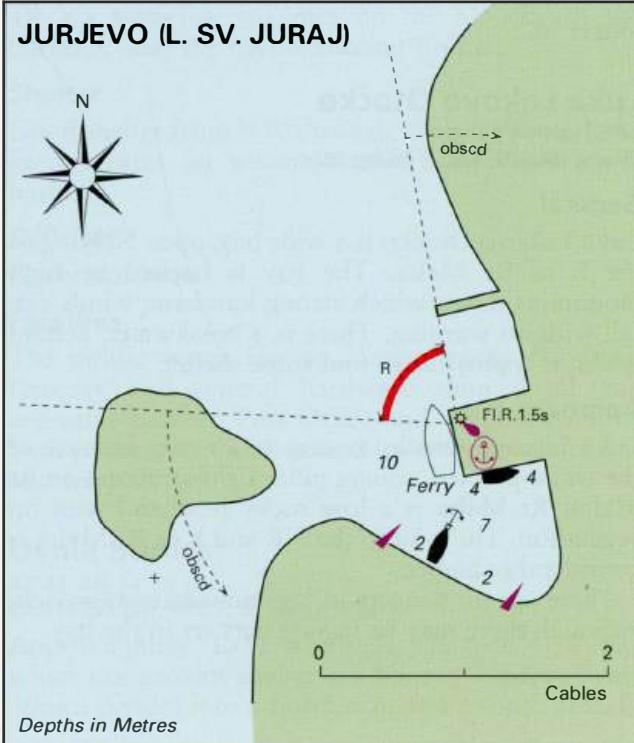
44°55".9N 14°55"-4E Charts BA 202, MK 7, lmray M24 Jurjevo is a small town and harbour on the mainland coast of the Velebitski Kanai approximately 4.4M north-northeast of Rt Malta. Jurjevo can be identified by the small island, which lies close W of the harbour. To the S of the village is a factory, Jurjevo Plastika. Approaching from N the church b
General
44°55".9N 14°55"-4E Charts BA 202, MK 7, lmray M24 Jurjevo is a small town and harbour on the mainland coast of the Velebitski Kanai approximately 4.4M north-northeast of Rt Malta.
Approach
Jurjevo can be identified by the small island, which lies close W of the harbour. To the S of the village is a factory, Jurjevo Plastika. Approaching from N the church belfry is also conspicuous. Pass to the of the island to enter the harbour. It is considered dangerous to attempt to enter the harbour in a strong bora. Pasman
Adriatic Navigation Guide Images for Jurjevo (Luka Sv. Juraj)
Adriatic Navigation Guide images and captions provide additional visual reference for this navigation location.