Jelsa
Region: South Adriatic
| Position: 43.163333, 16.7 | Adriatic Sea / Jadransko more
43°09'.8N 16°42'E Charts BA 2772, SC 5767, MK 79, lmray M26 Jelsa is an attractive small town surrounded by green hills. It is popular with tourists and not as quiet at Vrboska. The harbour is an interesting port of call in summer, but the hara makes it dangerous in winter. Ferries and the hydrofoil create a wash in the harbour, which is a nuisance
General
43°09'.8N 16°42'E Charts BA 2772, SC 5767, MK 79, lmray M26 Jelsa is an attractive small town surrounded by green hills. It is popular with tourists and not as quiet at Vrboska. The harbour is an interesting port of call in summer, but the hara makes it dangerous in winter. Ferries and the hydrofoil create a wash in the harbour, which is a nuisance.
Approach
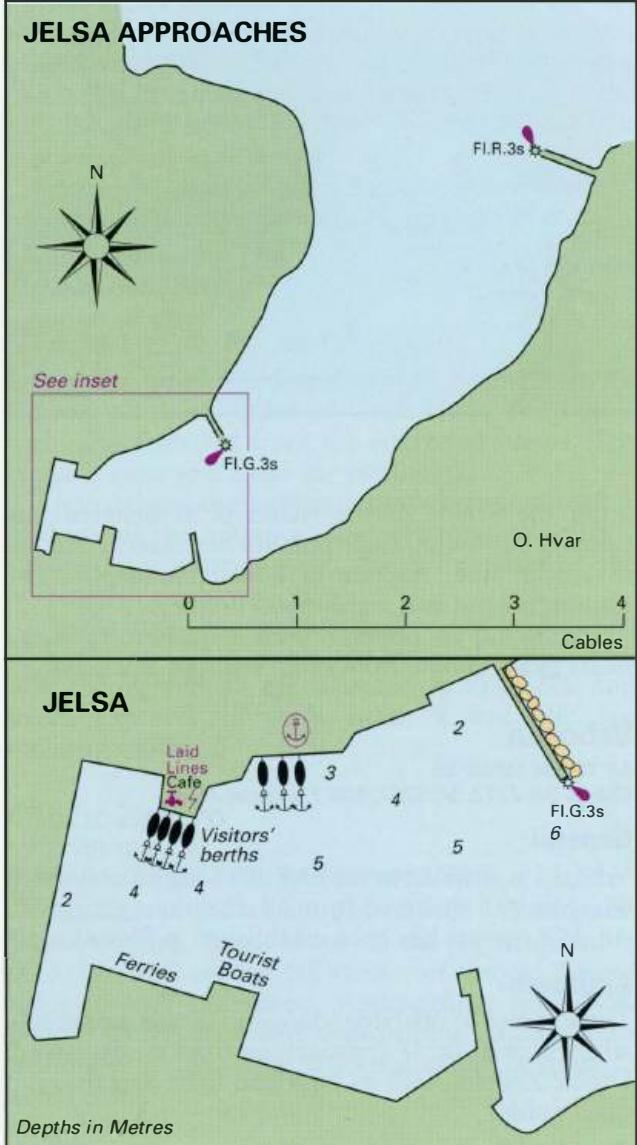
The inlet and harbour are easily identified by day or night. Approaching from N the town with its tall church spire or belfry is conspicuous. Approaching from E the town does not come into view until the bay opens up. There are no dangers in the immediate approach.
Lights
Otocic Zecevo Fl.5sllm5M Rt Sv. Kriz Fl.2s5m5M Jelsa (outer breakwater) Fl.R.3s6m5M Jelsa (inner N mole head) Fl.G.3s7m4M
Berth
Visitors' berths are mainly on the N side of the harbour, near the Harbourmaster's office. Pick-up lines have been provided.
Shelter
The outer part of the harbour is exposed to winds from N and NE and can be dangerous in strong winds from these directions. If strong winds from the NE are forecast it is advisable to move to Vrboska. The yacht berths at Jelsa are subject to a dangerous reflected swell in these conditions.
Officials
Harbourmaster and police. '. , . . ' ;; . Looking across Jelsa harbour towards the visitors' berths
Facilities
Water and electricity have been laid onto the visitors' quay on the N side of the harbour, and to the S quay. Fuel is available from the petrol station near the market (follow the road, which leads W out of the town near the park). Several grocery shops including a large wellstocked supermarket. Bakers. Daily fruit and vegetable market, butcher. Hardware shop. Banks, ATMs and currency exchange office. Post Office and telephones. Internet cafe. Tourist information, hotels, restaurants, cafe/bars. Medical centre and pharmacy. Bus and ferry service. Car hire.
History
Jelsa was founded in the 14th century as a landing place and harbour for the inland village of Pitve. The harbour, however, was not quayed until 1830. In the late 14th century and at the beginning of the 15th century the population was increased by refugees from Bosnia. More refugees came from Makarska during the 17th century. There are a number of interesting buildings in and around Jelsa, including the fortified church, which helped protect the villagers from the Turkish attack in 1571, the ruins of a Greek watchtower outside the town, and a ruined fortress built on Illyrian foundations with Roman additions, which lies on a cliff to the E of the town. There are some pleasant walks from Jelsa to neighbouring villages, including a walk along a coastal road to Vrboska. Vela Stiniva
Adriatic Navigation Guide Images for Jelsa
Adriatic Navigation Guide images and captions provide additional visual reference for this navigation location.