Hodilje
Region: South Adriatic
| Position: 42.858333, 17.693333 | Adriatic Sea / Jadransko more
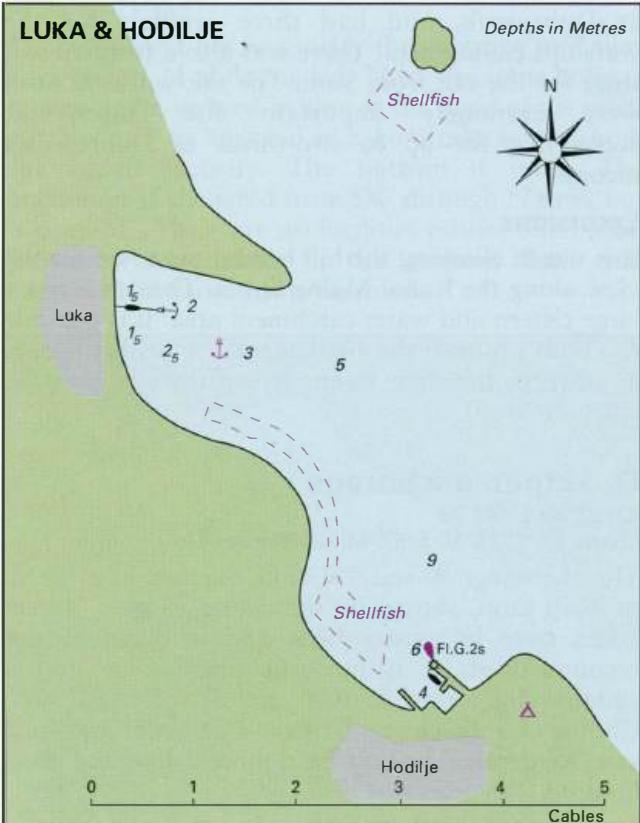
42°51"5N 17°41"6E Charts BA 7574, SC 5767. MK 24, 25. lmray M26 Hodilje is a small shell-fishing and vine-growing hamlet with narrow twisting alleys climbing the hill. It lies lM northwest of Mali Ston on the Pelje5ac peninsula. There is a mole, behind which it is possible to shelter. Hodilje lies on the SW side of the channel lM northwest of Mali
General
42°51"5N 17°41"6E Charts BA 7574, SC 5767. MK 24, 25. lmray M26 Hodilje is a small shell-fishing and vine-growing hamlet with narrow twisting alleys climbing the hill. It lies lM northwest of Mali Ston on the Pelje5ac peninsula. There is a mole, behind which it is possible to shelter.
Approach
Hodilje lies on the SW side of the channel lM northwest of Mali Ston. There is a light structure (painted white) on the end of the mole which helps identify the harbour. Note that the shores NW and N of Hodilje have shell-fishing buoys and stakes close offshore, which should be avoided, especially if arriving in poor light.
Lights
Hodilje mole head Fl.G.2s7m3M Rt Celjen Fl.3s10m6M
Berth
Tie up alongside the mole. There is 3m on the inner side. Anchor It is possible to anchor N of the mole in 9m. The bottom is mud, good holding.
Shelter
Although the bora blows strongly in this area allround shelter is available behind the mole.
Facilities
There is a campsite near the harbour, and a shop where essential foodstuffs can be bought. Mali Ston
Adriatic Navigation Guide Images for Hodilje
Adriatic Navigation Guide images and captions provide additional visual reference for this navigation location.