Gradac
Region: South Adriatic
| Position: 43.103333, 17.346667 | Adriatic Sea / Jadransko more
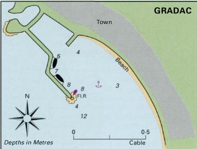
43°06'.2N 17°20'.8E Charts BA 1574, SC 5767, MK 20, lmray M26 Gradac is a popular holiday resort with a small harbour. The harbour walls are usually draped with sunbathers, or doing service as diving platforms. The visiting yacht attracts much attention here, but if you do not mind this, there are a number of restaurants ashore to tempt your palate
General
43°06'.2N 17°20'.8E Charts BA 1574, SC 5767, MK 20, lmray M26 Gradac is a popular holiday resort with a small harbour. The harbour walls are usually draped with sunbathers, or doing service as diving platforms. The visiting yacht attracts much attention here, but if you do not mind this, there are a number of restaurants ashore to tempt your palate.
Approach
Gradac is in a bay SM northwest of Rt Vifojica. The church on the NW headland and the conspicuous monument (a tall white pillar with a winged figure on top) help identify Gradac. In the closer approach, the harbour wall is obvious. Approaching from W or NW note that there is a small-boat harbour NW of the harbour itself, and seeing a small fishing boat entering or leaving can be confusing. This small-boat harbour is too shallow and cramped for even the smallest yacht. Entering the harbour beware of swimmers, and some underwater blocks extending from the end of the breakwater. There are no lights.
Shelter
Protected from SW through N to SE, but Gradac is dangerous in strong S winds. In these conditions, strong currents may be encountered off the harbour.
Facilities
The public water tap near the harbour no longer works. Several food shops. Post Office. Bank. ATM. Tourist information. Hotels, restaurants, cafe/bars, discos. Telephones. Bus service. Brist 43°0TN 17°19..7E Podaca 43°0T-6N 1r1s..2E Zaostrog (Kraj) 43°os..2N 1r1r-2E Charts BA 1574, SC 5767, MK 20, lmray M26 All the above holiday resorts have piers used by tripper boats. In settled weather, it is possible to anchor off the beaches for swimming, but they are too exposed to be recommended as overnight anchorages. Uvala Drvenik (Donja Vala)
Adriatic Navigation Guide Images for Gradac
Adriatic Navigation Guide images and captions provide additional visual reference for this navigation location.