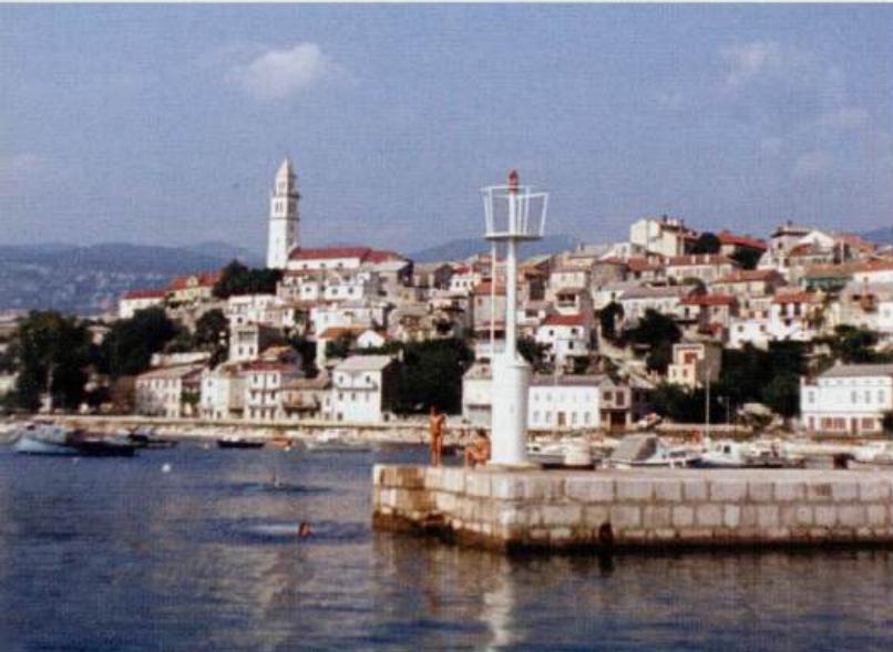
Crikvenica
General
45°10'.3N 14°41'.7E Charts BA 2719, MK 5, lmray M24 Crikvenica is a busy holiday town with a small but bustling harbour. A second harbour for locally owned boats has been built to the E, just beyond the river mouth. In between, to the W of the river mouth, is a fuel berth. Every year on 15 August a swimming marathon is held when the participants swim across the channel between Silo on Otok Krk and Crikvenica.
Approach
The large viaduct over the gorge to the E of the town is conspicuous. There are light structures on the end of the main breakwater and on the pier on the W side of the river entrance. Confusingly both lights show the same characteristic (Fl.G.2s). The mainland coast on either side of Crikvenica harbour is bordered by a shallow bank. Two red can buoys mark the seaward edge of the bank to the NW of the harbour, and a green buoy marks the seaward end of the shallows to the SE of the harbour. If entering the main harbour pass between the more S red buoy and the harbour breakwater to the S. At night take particular care because none of the buoys are lit. If going to the fuel berth, pass S of the green buoy. There are depths of Sm in the approach to the main harbour and 4m in the approach to the fuel berth. . 3.4 Croatia: Senj to border with Slovenia -Mainland coast ' ' . ..... ' ".: A. --, : . L L Entering the main harbour at Crikvenica Bakarski Zaljev is entered between Rt Molnaric to the NW and Rt Ostro to the SE. The entrance can be identified by a large tank farm and a tall chimney painted with red and white bands to the W of the entrance. A shallow bank extends nearly 2 cables NW from Rt Ostro. Its NW end is marked by a lit green buoy (Fl.G.3s). 4 cables W of this buoy and 2 cables SW of Rt Molnaric lies an isolated rocky patch with depths of lOm over it. In certain conditions this can cause rough seas. Within the Bakarski Zaljev some isolated rocks lie close to the shore in the approaches to Bakar. The ship channel up to Bakar is marked by buoys. Fishing nets are sometimes set in the S part of the Bakarski Zaljev, in the approaches to Bakarac.
Lights
Crikvenica breakwater Fl.G.2s8m3M River entrance pier Fl.G.2s7m4M Rt Silo Fl.3s14m7M Rt Tokal Fl.6s20m9M Rt Srednji Fl(2)5s12m5M 212.5°-vis-053° Buoy off Rt Ostro Fl.G.3s4M Luka Kraljevica pier ER and Fl.3s6m3M Rt Babno Fl.R.2s12m4M Rt Kavranic Fl.5s15m6M
Berth
There are three options for berthing at Crikvenica: Main harbour Visiting yachts should tie up beyond the ferry berth in the space allocated for visitors. There are buoys here for taking stern lines. Alongside the quay are depths of 3m. On arrival report to the tourist information office, which administers these berths. Harbour dues are charged. River entrance It is possible for a visiting yacht to tie up just inside the river entrance in good weather. There are rings and bollards along the quay for taking lines. Near the entrance there are depths of 4m, decreasing to 2m farther up. A low road bridge crosses the river a short distance from the entrance. There are underwater rocks off the end of the S wall. New harbour It may be possible to anchor and take lines ashore to the rough rubble breakwater, which protects the small harbour from S. There are depths of 3m inside. The harbour is crowded and there may be no room for visitors. Each of the harbours in the Bakarski Zaljev (Kraljevica, Bakarac and Bakar) are described below separately. the inlet, beyond the modern industrial installations Kraljevica
Shelter
The harbour is sheltered from N through E to SE. The new harbour is also sheltered from S. CRIKVENICA 0 0.5 Depths in Metres Cable . :�'.\ ', '
Officials
Harbourmaster. Police.
Facilities
Petrol and diesel are available from the fuel quay, which lies to the E of the harbour near the river mouth. There are depths of 3m alongside the fuel quay. Water is laid on to the main harbour breakwater. Enquire at the tourist information office. Several supermarkets. Butchers. Fruit and vegetable market. Banks, ATM, Post Office and telephones. Medical centre and pharmacy. Tourist information, hotels, restaurants, and cafe/bars. Excursions. Bus service to Rijeka and other local destinations. Taxis and car hire. Mechanical workshop. 2-ton crane and slipway at the new harbour. Diving centre, where air bottles can be refilled.
History
Up until the 19th century Crikvenica was a small fishing village. All this changed when a new coastal road was built linking up the coast villages. Soon after the road was built hotels and villas were constructed, gardens and parks laid out, and the harbour enlarged and improved. Today Crikvenica is a busy holiday resort and spa. The so-called F rankopan castle in the town was built in 1412 and was originally a monastery, which was dissolved in 1786. The building has been used as a home for sick soldiers and as a children's home. Uvala Brsljanovica (Uvala Kacjak) 45"12"N 14"39".5E Charts BA 2779, MK 5, lmray M24 2.3M northwest of Crikvenica, to the east of Rt Kacjak (a steep whitish coloured headland), lies Uvala Brsljanovica. Uvala Br5ljanovica is a cove where it is possible to obtain shelter from W through N to E. On the E side of the cove are a mole and a quay, and at the head of the cove a slipway. A yacht wishing to obtain shelter here should anchor in lOm and take lines ashore (because of the depth and lack of swinging room). Uvala Percin (Jadranovo) 45"13".6N 14"37"-1 E Charts BA 2779, MK 5, lmray M24 Uvala Percin is a bay at the SE end of the Tihi Kanai, on the mainland coast, approximately M north of Rt Ertak. The bay is considered to offer the best shelter against the bora and the sirocco in the Tihi Kanal. Depths in Uvala Percin are in excess of 18m. A yacht wishing to shelter here should either go alongside the quay with the light (ER.3M) on the N side of the bay, or bow-to amongst the local boats, which are moored on the S and E sides of the bay. Depths alongside the quay with the light are 4m. Uvala PerCin offers good shelter from alf wind directions. Ashore there are several cafe/bars overlooking the bay, and there is a shop in the village. There is also a 3-ton crane on the quay. BAKARSKI ZALJEV Charts BA 2779, 1996 (detailed), MK 5, lmray M24 Bakarski Zaljev is a landlocked basin, approached through a channel 3 cables wide at its narrowest point,,which lies in the mainland coast SE of Rijeka and N of Otok Krk. The basin comes under the jurisdiction of the Rijeka port authority, and has facilities for ships. There is a shipyard at Kraljevica, and an oil terminal and bulk cargo handling facilities on both sides of the Bakarski Zaljev in the approach to Bakar. Bakarac, at the SE end of Bakarski Zaljev, with its small harbour and anchorage, offers a pleasant berth for a yacht, although the bora is felt strongly here.
Adriatic Navigation Guide Images for Crikvenica
Adriatic Navigation Guide images and captions provide additional visual reference for this navigation location.