Broce
Region: South Adriatic
| Position: 42.821667, 17.72 | Adriatic Sea / Jadransko more
42°49'.3N 17°43'.2E Charts BA 1580, SC 5767. MK 25. lmray M26 Broce is a small picturesque village with a campsite. It lies at the narrow entrance to the marked channel which leads up to Ston. The little port was used by small coasters coming to load salt from the salt pans of Storr. Approaching Broce the depths in the Stonski Kanai decrease from o
General
42°49'.3N 17°43'.2E Charts BA 1580, SC 5767. MK 25. lmray M26 Broce is a small picturesque village with a campsite. It lies at the narrow entrance to the marked channel which leads up to Ston. The little port was used by small coasters coming to load salt from the salt pans of Storr.
Approach
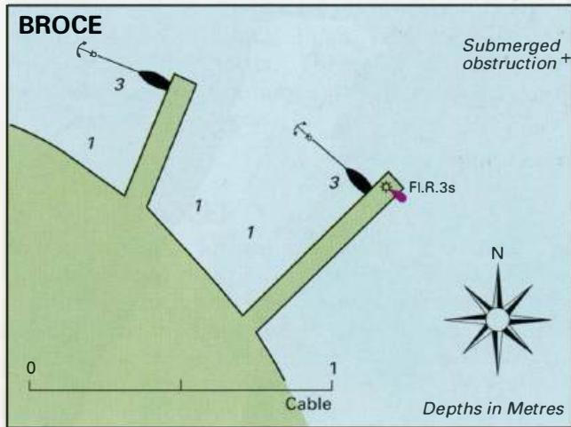
Approaching Broce the depths in the Stonski Kanai decrease from over 7m to 4m. Sound your way carefully here because the depths in the channel can change, especially after SE winds. The channel has to be dredged to keep it open. We found a minimum of 4m, but according to one source the channel from Broce to Ston is only kept dredged to 2.5m! There have also been reports that dredging has been discontinued, so it may be advisable to check on the current situation at Broce before proceeding up to Ston. On nearing Broce, keep close to the head of the mole with the light on its end to avoid a submerged obstruction approximately 0.4 cables NNW of the mole head.
Lights
Rt Pologrina (Grbljava) Fl.3sllm7M Broce molehead Fl.R.3s6m4M
Berth
Tie bow or stern-to one of the quays as space and depths allow.
Shelter
Good shelter from the seas, but the winds, especially SE and NW are felt strongly here because of the funnelling effect of the hills.
Facilities
Restaurant and bar.
History
Broce was founded by the Dubrovnik Republic in 1349. There are three old chapels nearby, as well as the ruins of a 17th-century Dominican monastery. St on
Adriatic Navigation Guide Images for Broce
Adriatic Navigation Guide images and captions provide additional visual reference for this navigation location.