Brindisi
General
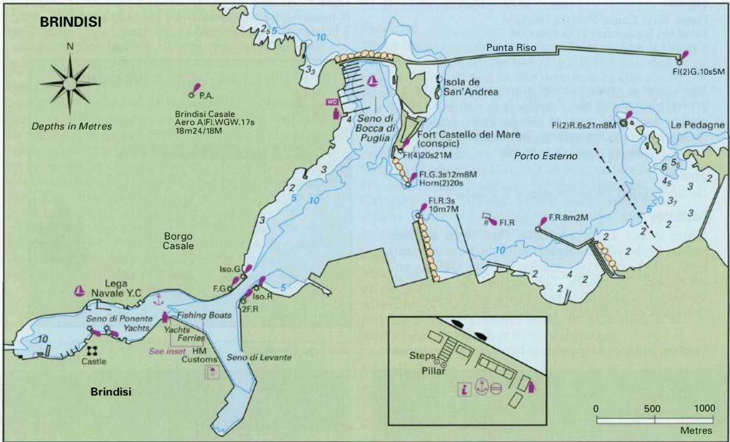
40°39'.6N 17°59'.8E Charts BA 186, 187, 188, 1418 (plan of harbour and approaches) Brindisi is a major ferry port and a large industrial and commercial centre. It is also a naval port with a military airfield close by. There is a large marina sheltered by Isola de Sant' Andrea in the outer part of the harbour.
Approach
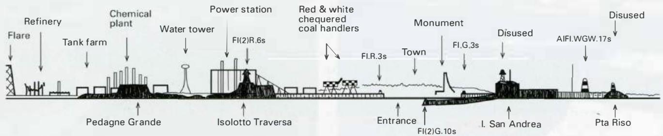
A number of small, low islands and areas of shallows lie in the approach to Brindisi. The land in the vicinity of Brindisi is low-lying making identification and the approach difficult, particularly in poor visibility. Refer to the sketch showing the prominent features for help with locating the entrance. There is also a diagram showing the approach and entry to the harbour. The area is well lit at night, as would be expected of a major port, but it can be difficult to distinguish the navigation lights against the background of the city lights. If approaching from N note that a breakwater, the Diga di Punta Riso, has been built extending E from Isola S Andrea. Approaching from S beware of the firing range extending up to SM offshore, which is located between Otranto and Brindisi, near Torre Veneri. There is another firing range around Punta Contessa, extending up to 2M offshore, where navigation, anchoring and fishing are prohibited. When this range is in use red flags are hoisted. Details of the firing ranges are shown on the charts and can also be obtained from local harbour offices. Beware of the area of rocks and shallows extending approximately lM offshore at Capo di Torre Cavallo E of Brindisi. There is a lit E cardinal beacon NE of Capo di Torre Cavallo and E of the entrance to Brindisi. From this beacon a course of 267° leads into the outer harbour.
Lights
E cardinal beacon E of harbour entrance Q(3)10s4m5M Diga di Punta Riso Fl(2)G.10s12m5M Pta Riso light discontinued End of the breakwater extending from the S end of Isola S Andrea Fl.G.3s12m8M Horn(2)20s Isolotto Traversa (Le Pedagne) Fl(2)R.6s21m8M 349°-vis-252° Y lights mark fish farm 7.5M WNW Aero (Casale) AIFl.WGW.l 7s18m18-24M Maio S breakwater Fl.R.3s10m7M Entrance to canal leading to the inner basin Iso.G.2s9m5M and Iso.R.2s9m5M Castello a Mare Fl(4)20s28m21M
Berth
If on passage, or if you want a hassle free berth, the best option is to berth at the marina located in the Seno di Bocca di Puglia (max. length 40m). For direct access to the town centre, berth in the innermost part of the harbour. The NE-facing quay, opposite the entrance canal and the monument, is where the Appian Way terminated in a flight of steps flanked by pillars. Today the quay is used by a large fishing boat fleet, yachts in transit and ferries. The best part of this quay for visiting yachts is tied up Brindisi's distinctive rudder shaped monument is located close to the entrance to the inner part of the harbour alongside, near the harbourmaster's office. This berth, however, is exposed to the wash from passing vessels and can be dangerous in bad weather. Another possible berth for visiting yachts is alongside the quay SW of the fuel berth, but note that in places there is a protruding stone ledge at sea level. The sailing club has berths on floating pontoons on the N side of the N arm, and welcomes visitors. These berths are not as troubled by wash or surge in bad weather. A shortcut across the harbour is provided by a nearby foot ferry. Anchor On the N side of the N arm in the position indicated on the diagram. Depths outside of the moorings are about 7m. The holding in mud is good. The anchorage can be uncomfortable but it is safer than being tied alongside in bad weather. Land by dinghy near the fishing boat quay.
Shelter
All-round shelter is available in Brindisi depending on the berth chosen. Brindisi Marina is located in the Seno di Bocca di Puglia in the outer part of the harbour
Officials
The harbourmaster's office and the customs office overlook the main quay just to the SE of the flight of steps. This is a naval harbour and the officials can be particularly zealous. Police in the town.
Facilities
Water, electricity, toilets, showers, ATM, fuel, restaurant, small chandlers, 100-ton travel hoist, repair and laying up facilities at the marina. There is a supermarket lOOm from the marina entrance. Water is available at the yacht club. On the main quay water can be obtained from standpipes, but a charge is made for this. If only a small quantity is required or you don't mind carrying it in containers there is a tap near the steps and a cast-iron dispenser near the fishing boat quay. Petrol and diesel from the fuel berth on the N-facing quay (see plan). Italian gas and Camping Gaz. Paraffin from an Agip depot, 12 Viale Commenda, near the railway station. There is an excellent selection of shops and supermarkets, including two large supermarkets on the main shopping street not far from the quay. Fruit and vegetable market. Fish is sold directly from the fishing boats when they return with their catch. Banks, ATMs, internet cafes, Post Office, telephones. Doctors, dentists, hospital, pharmacies, veterinary surgeon. Extremely helpful tourist information office on the main quay. Many helpful maps and leaflets as well as advice are freely available here. Hotels, restaurants and cafe/bars. Showers are available at a building on the W quayside of the Senno di Levante. Railway station, bus service, ferries to Greece, Croatia, Montenegro and Albania, airport (used by budget airlines), car hire, taxis. Chandlers, hardware stores, engineering supplies, electronic components. The chandler located in the alleyway behind the customs office has a limited range of Admiralty charts as well as Italian charts. All kinds of repairs can be carried out. The marina address is: Marina di Brindisi, Bocca di Puglia spa, v. Dardanelli, localita Rione Casale, 72100 Brindisi -a-0831 411516 Fax 0831 414381 Email [email protected] www.marinadibrindisi.it The fuel berth at Brindisi Marina
History
Brindisi has been a major port for thousands of years. The natural harbour was in use long before the Romans arrived. The Messapians used the harbour and it is from their word for 'deer' that the name of Brindisi is derived. During Roman times the Appian Way terminated here, and Brindisi was the major port connecting Rome to its eastern provmces. After the fall of the Roman Empire Brindisi was occupied by various conquerors. These conquerors and earthquakes contributed to the port's gradual decline, which was only reversed towards the end of the 19th century with the increase in industrial activity and ferry traffic. There are a number of interesting monuments illustrating the town's history. A map of Brindisi lists these. The museum is worth a visit, as is the memorial to sailors, which is shaped like a rudder. There is a superb view from the top of this memorial, but unfortunately cameras are prohibited (because of the nearby naval installations). Santa Foca di Melendugno
Adriatic Navigation Guide Images for Brindisi
Adriatic Navigation Guide images and captions provide additional visual reference for this navigation location.