Bol
Region: Central Adriatic
| Position: 43.261667, 16.663333 | Adriatic Sea / Jadransko more
43°15'.7N 16°39'.8E Charts BA 2712, SC 5767, MK 18, 19, 20, lmray M26 Bo! is the largest settlement on the S coast of Brae. It is overshadowed by the mountain of Vidova Gora, 2M northwest. The walk up to the summit of Vidova Gora from Bo! takes approximately 2 hours. The town is easily recognised from seaward and there is a conspicuous monastery wi
General
43°15'.7N 16°39'.8E Charts BA 2712, SC 5767, MK 18, 19, 20, lmray M26 Bo! is the largest settlement on the S coast of Brae. It is overshadowed by the mountain of Vidova Gora, 2M northwest. The walk up to the summit of Vidova Gora from Bo! takes approximately 2 hours.
Approach
The town is easily recognised from seaward and there is a conspicuous monastery with spire to the E of the town. To the W of the town, near Dugi Rat, there is a large complex of white buildings with solar panels. Approaching from W or S beware of the low shingle bank and shoal water which extends at least 2 cables S from Dugi Rat, approximately lM west of Bo!. This spit can be difficult to see. A yellow buoy Fl.Y.5s4M lies approximately 2 cables off the end of the spit. There are no other dangers in the approach.
Lights
Bol pier Fl.G.3s7m3M
Berth
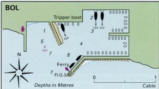
Tie up bow/stern-to the quay in the harbour (see plan), or alongside the breakwater. Anchor It is possible to anchor E of the fuel berth, but this is not so sheltered.
Shelter
The bora blows strongly here. The harbour is exposed to SW winds, which create big seas, and is uncomfortable in winds or swell from S. The shelter is good from other directions.
Facilities
Petrol and diesel are available between 0600 and 2200 from the quayside filling station. Depths alongside are 3.5-4m. Supermarket, butcher, and a fruit and vegetable market. Bank, ATM and Post Office. Telephone. Medical centre. Hotel, restaurants, cafe/bars. Open-air cinema. Art gallery. Bus service. Uvala Lucice