Bl ace
General
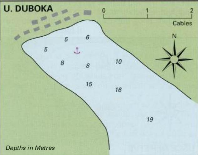
43°00'.01 N 17°28'.9E Charts BA 1574, SC 5767. MK 24. lmray M26 The small hamlet of Blace is to be found just over SM northwest of Rt Rep Kleka, and northeast of the light on 0. Skoljic. Behind the island is a quiet cove offering good all-round shelter, but limited facilities. We had a very friendly reception at Blace. Our mooring lines were taken for us and we were then personally conducted to the one shop in the hamlet!
Approach
If approaching from the direction of Place (Kardeljevo) give the mouth of the river Neretva a wide berth because of off-lying sandbanks. Blace lies nearly 2M southeast of the Neretva river mouth. It can be identified by OtoCic Skoljic, the island with the on it lying off the hamlet. Pass to the SE of 0. and into the basin beyond. There is a minimum depth of 2.5m in the passage.
Lights
Otocic Skoljic Fl.R.2s6m3M l 78°-vis-088°
Berth
Tie up alongside the quay on the NE side of the basin, where there is a minimum depth of 2m. Anchor Anchor in the centre of the basin in 7m. The bottom is sticky mud, excellent holding.
Shelter
Good all-round shelter, although the bora blows strongly in this area.
Facilities
One general grocery shop only. This is situated on the far side of the shallow inner basin. Telephone. THE NERETVA RIVER Charts BA 1574, SC 5767. MK 24. lmray M26 The Neretva River (Rijeka Neretva) is one of the most important rivers in Croatia. It rises some distance away in the mountains, and is joined by many tributaries before entering the sea south of Place (Kardeljevo). The delta region is marshy and noted for its wildfowl and fish life. Towards the end of the 1880s parts of the delta were drained, drainage channels were constructed, and the main river modified, improving access to the inland port of Metkovic from the sea. Today, small coasters still ascend the river to the ports of Opuzen and Metkovic, 1 lM upstream. The importance of Metkovic is indicated by the fact that it is one of the ports of entry open throughout the year. The Neretva River delta is a rich agricultural area, apparently producing two harvests a year. The interlinking river channels provide an important system of communications for the local farmers who can be seen transporting produce or reeds in their traditional wooden craft called trupice. Since 1999 there has been an annual race or marathon of these traditional trupice and ladje (barges) from Metkovic to Place. It is possible to explore many of these channels by canoe or dinghy. The economic and strategic importance of the Neretva delta has long been recognised. Julius Caesar, during his campaigns in this area, stayed at Narona (the present-day Yid, NW of Metkovic) in 57BC. The people of the Neretva delta were sufficiently powerful to be able to impose tolls on Venice to allow the safe passage of Venetian ships in the area. Venice gained control of the area during the 13th century, but this control was frequently challenged by the Turks. Yachts, drawing a maximum of 4.5m and with an air height of less than 14m, can enter the river and proceed as far as Metkovic, where a low road bridge prevents further progress. Entering the river requires care because of the off-lying sandbanks, but the entrance is buoyed with lightbuoys (see plan). The channel may change with time from that shown, and depths will vary. We found minimum depths of Sm in the channel during the summer after a prolonged dry spell. The Admiralty Pilot, however, warns that there are depths of 3.7m over the bar. The wise course of action is to sound your way in, only attempting it in good weather, and keeping to the dredged channel. The boards at the river entrance, which used to give details of the depths in the river entrance, have been discontinued. The mole heads at the mouth of the river are lit (Fl.R.2s6m4M and Fl.G.2s5m5M). The water level at the mouth increases during NW winds and during the rainy season. The current is normally 2 knots, but during the rainy season it can increase to 5 knots, or in exceptional circumstances, to 7 knots. During the summer months, there is usually a breeze blowing downriver during the morning, but this reverses from midday. The bora blows very strongly in this region, particularly at Norinska Kula (3M downstream of Metkovic) where high land to either side forms a narrow gorge through which the wind is funnelled. Just over lM from the river entrance high-tension cables cross the river, with an air clearance of 45m. A little under a mile further on there is a road bridge, which has a clearance of 14m. Half a mile beyond the road bridge, a shoal extends almost a third of the way across the river from the NW bank. There is a quay at Opuzen. The Mala Neretva branches off outhwards at Opuzen. If proceeding beyond Opuzen note that another shoal there extends approximately a third of the way across the river from the S bank (near the Mala Neretva). There are a number of other areas in the river, where there are shallower depths, but these are obvious in good light. The river is marked at intervals by navigation lights (Fl.R.3s and Fl.G.3s). It is possible to tie up alongside the quay at Opuzen, where there is 3.5m alongside. There are quays on the N and S side of the river at Metkovic. The N quay has 4m alongside, and the S side has 2.5m alongside. Yachts should use the S quay. Metkovic is a reasonable-sized town with shops, bank, Post Office, and a railway station. The Neretva River is used by ships as well as by the trupice, so it is particularly important for yachts to obey the navigation regulations. Yachts must keep to starboard, and, if going upstream, must give way to vessels coming from the opposite direction. Ships have right of way over yachts. Navigation is prohibited during fog, but is permitted during the hours of darkness. Vessels coming downstream must be able to drop an anchor from the stern in case of emergency. Anchoring is permitted within the river, but yachts and their tenders must not obstruct the fairway. At night, an additional white anchor light should be shown from the stern, as well as the normal anchor light shown at the bow. Place (Kardeljeva)
Adriatic Navigation Guide Images for Bl ace
Adriatic Navigation Guide images and captions provide additional visual reference for this navigation location.